2. That which projects like an ear, esp. that by which anything is supported, carried, or grasped, or to which a support is fastened; an ear; as, the lugs of a kettle; the lugs of a founder's flask; the lug (handle) of a jug.
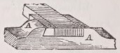
3. A projecting piece to which anything, as a rod, is attached, or against which anything, as a wedge or key, bears, or through which a bolt passes, etc.
4. The leather loop or ear by which a shaft is held up.
LUGANO, a town of Switzerland, which divides with Locarno and Bellinzona the first rank in the canton of Tessin (Ticino). It stands on the shore of the lake of the same name, on a narrow strip of Swiss territory which projects into Lombardy and is everywhere close to the Italian frontier. The prosperity of the town is due to its position on the main line of land communication between Milan and the pass of the St Gotthard, and the facility of intercourse by land and water, whether for legitimate or contraband trade, between this outlying fragment of Switzerland and the rich region that surrounds it. The buildings are not remarkable, but the church of Santa Maria degli Angioli contains several important pictures by Luini, a native of the adjoining district. The monastery to which the church formerly belonged is now converted into a large hotel. During the struggle of the people of northern Italy to expel the Austrians from Lombardy, between the years 1848 and 1866, Lugano served as headquarters for Mazzini and his followers. Books and tracts intended for circulation throughout Italy were produced there, and at the neighbouring village of Capolago, on a large scale, and the efforts of the Austrian police to check their circulation were completely powerless. The population is Italian in character and features, and the Italian tongue is exclusively spoken. On the quay is a statue of Tell by Vela, and there are other works by the same eminent sculptor, a native of the canton, in private grounds near the town. About 2 miles distant, and nearly due south, a steep hill—called Monte Salvatore—rises more than 2000 feet above the surface of the lake, and commands a fine panoramic view, limited in some directions by the higher mountains on the opposite side of the lake, but ...extending in one direction to Monte Rosa, and in another to the cathedral of Milan.
LUGANO, Lake of (sometimes called Lago Ceresio by the Italians, from the Roman name Lacus Ceresins'), situated partly in Lombardy and partly in the Swiss canton Tessin or Ticino, takes its ordinary name from the town of Lugano, the only considerable place on its banks. Its form is very irregular, and has been compared to a sickle, a fish-hook, and various other objects. It lies altogether amidst the outer ranges of the Alps that divide the basin of the Ticino from that of the Adda, where the calcareous strata have been disturbed by the intrusion of porphyry and other igneous rocks. It is not connected with any considerable valley, but is fed by numerous torrents in various directions issuing from short glens in the surrounding mountains, and is drained by the Tresa, an unimportant stream that flows westward into the Lago Maggiore. The surface of the lake is 889 feet above the sea, and the form of its bed seems to be very irregular. In some parts soundings of more than 1000 feet have been taken, while in one place the lake is so shallow that a causeway half a mile in length, supporting the road and the railway, has been carried from shore to shore. The scenery is of a varied character: in great part, and especially in the north-east arm extending from Lugano to the Lombard village of Γorlezza, the lake is enclosed between mountains that rise steeply to a height of some 2000 feet from the water’s edge, while on its southern and western branches it is encompassed by gently swelling hills rich with the luxuriance of Italian vegetation.
9th ed. Encyclopædia Britannica, vol. 15, p. 60 [319 words — estimated reading time: 2 minutes]
LUGANSK, a town of Russia, in the government of Ekaterinoslaff, district of Slavianoserbsk, 300 miles to the eastward of the capital of the province, is connected by a branch with the railway between Kharkoff and Azoff, as well as with other towns and iron-works of the Donetz coal-mines district. It stands on the small river Lugan, 10 miles from its junction with the northern Donetz, in the Lugan mine district, of which it is the chief town. This district, which comprises the important coal-mines of Lisi-tchansk and the anthracite mines of Gorodische, occupies an area of about 110,000 acres on the banks of the Donetz river, and has a population of more than 15,000. Although it is mentioned in Russian history as early as the 16th century, and coal was discovered in it at the time of Peter I., it was not until 1795 that an Englishman, Gascoyne or Gaskoin, established its first iron-work for supplying the Black Sea fleet and the southern fortresses with guns and shot. This proved a failure, owing to the great distance from the sea, and the manufacture of supplies for the navy was suspended; but during the Crimean war the iron-works of Lugan again largely produced shot, shell, and gun-carriages. Since 1864 agricultural implements, steam-engines, and the various machinery required for beetroot sugar-works, distilleries, <fcc., have been the chief manufactures. The Lugan works, which employ about 1200 men, are the chief centre for smelting the ores of the neighbouring iron-mines. The town is the seat of the mining authorities for the district, and has a first-class meteorological and magnetic observatory. The 11,000 inhabitants of Lugansk also carry on a very active trade in cattle, tallow, wools, skins, linseed, wine, corn, and manufactured wares. The weekly fairs are much ...frequented. There are also in the town many tallowmelting works, and the smith trade is largely carried on.
‘ LUGO, a maritime province of Spain, one of the four into which Galicia has since 1833 been divided, is bounded on the E. by Oviedo and Leon, on the S. by Orense, on the W. by Pontevedra and Coruna, and on the N. by the Atlantic. Its extreme length from north to south is about 98 miles, its breadth 58, and the area 3787 square miles. The coast, which extends for about 40 miles from the estuary of Rivadeo to Cape Vares, is extremely rugged and inaccessible, and few of the inlets that exist, except those of Rivadeo and Vivero, admit vessels of any size. The province, especially in the north and east, is mountainous in its character, being traversed by the great Cantabrian chain and its offshoots; the sierra by which it is separated from Leon attains in some places a height of 6000 feet. A large part of the area is drained by the Mino, which rises on the western slope of the Sierra de Meira, and follows a southerly direction until it is joined by the Sil; the latt·er for a considerable distance forms the southern boundary of the province. Of the rivers of the northern versant the most important are the Navia (which has its lower course through Oviedo), the Eo (for some distance the boundary between the two provinces), the Masma, the Oro, and the Landrobe. The Eume, one of the rivers of Coruna, and the Ulla, which separates that province from Pontevedra, both have their rise on the western slopes of Lugo. Some of the northern valleys even, in their lower portions, are fertile, and yield not only corn but fruit and wine, but the principal agricultural wealth is on the Mino and Sil, where rye, maize, wheat, legumes of various kinds, flax, hemp, and a little silk are produced. The hills are comparatively well wooded. Iron is found at Cancel and Incio, antimony at Castroverde and Cervantes, argentiferous lead at Riotorto; and there a:e quarries of granite, marble, and various kinds of slate and building stone. Linen and woollen cloths are manufactured, but to an insignificant extent, and the trade of the province is unimportant. The internal communications are still very imperfect. There is only one railway, that connecting Lugo with Coruna; but connexions with Leon (Branuelas) and with Orense are in contemplation. The total population in 1877 was 410,387, being a decrease of 22,129 since 1860. There are ten towns with a population over 10,000 —Chantada, Fonsagrada, Lugo, Mondonedo, Monforte, Panton, Sarria, Savinao, Villalba, and Vivero.
Lugo, the capital of the above province, stands on a small hill near the northern bank of the river Mino, at a height of 1930 feet above the level of the sea, 60 miles south-west from Coruna, and 353 north-west from Madrid, on the highway between these two cities. With the former it is continuously connected by rail. The form of the town, which is nearly quadrangular, is defined by a massive Roman wall, from 30 to 40 feet in height and 20 feet thick, with projecting semicircular towers which, prior to the civil war in 1809, were eighty-five in number; it now serves as a promenade, commanding an extensive and delightful prospect. The principal public places are the Plaza de la Constitucion, a spaciousarcaded square, the Plaza de San Domingo, the Plaza del Hospital, and the busyPlaza del Campo, where fairs and markets are held. The most important of the public buildings is the Gothic cathedral on the south side of the town; it dates from the 12th century, but was modernized in the 18th, and possesses no special architectural merit. Other churches are those of the Capuchins and that of San Domingo; the only other buildings of note are the episcopal palace, the secondary school, the hospital, and the prison. The principal industries are tanning, and the manufacture of linen cloth and of cream of tartar; there is some trade in silk wares. About a mile to the south of the town, on the left bank of the Mino, are the famous hot sulphur baths of Lugo; the bathing house dates from 1847. The population of the ayuntamiento in 1877 was 18,909.
Lugo {Lucus Augusti) was made by Augustus the seat of a conventus juridicus. Its sulphur baths were even then well known. It suffered greatly in the 5th century, during the Moorish wars, and, more recently, during the war of independence. The bishopric dates from a very early period, and it is said to have acquired metropolitan rank in the middle of the 6th century; it is now suffragan to Santiago.
9th ed. Encyclopædia Britannica, vol. 15, p. 60 [1,105 words — estimated reading time: 7 minutes]
LUGOS, a market-town of Hungary, capital of the trans-Tisian county of Krassô, is situated on the Ternes, and on the railway from Temesvâr to Karânsebes, 32 miles east-south-east of the former, in 45° 4Γ N. lat., 21° 53' E. long. The two main portions of the town, separated by the river, and named respectively Német- (German) Lugos and Rom<4n- (Roumanian) Lugos, are connected by a wooden bridge 312 feet in length. Lugos is the seat of a Greek Catholic (Roumanian) bishopric, of royal and circuit courts of law, and of the usual bureaus of a county administration. The public and other buildings include Greek Orthodox, Greek Catholic, Roman Catholic, and Lutheran churches, a synagogue, a royal upper gymnasium (founded in 1823), a Minorite convent, an episcopal palace, the barracks, and the ruins of a castle. The surrounding country is mountainous and well-wooded, and produces large quantities of grapes and plums. In 1880 the population was 11,287, of whom 3476, chiefly Germans, were in Német-Lugos, and 7811, Roumanians, with a few Slavonians and Magyars, in Român-Lugos.
Lugos was once a strong fortress and of greater relative importance than at present. During the 16th and 17th centuries it suffered much at the hands of the Turks. At the close of the Hungarian revolutionary war (August 1849) it was the last resort of Kossuth and several other leaders of the national cause previous to their escape to Turkey.
9th ed. Encyclopædia Britannica, vol. 15, p. 61 [249 words — estimated reading time: 2 minutes]
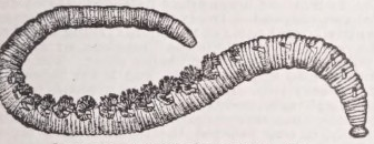
A large marine annelid (Arenicola marina) having a row of tufted gills along each side of the back. It is found burrowing in sandy beaches, both in America and Europe, and is used for bait by European fishermen. Called also lobworm, and baitworm.
V. hear, overhear, hark, harken, list, listen, pay attention, take heed, give an ear, lend an ear, bend an ear, catch, catch a sound, prick up one's ears, give ear, give a hearing, give audience to, hang upon the lips of, be all ears, listen with both ears, become audible, meet the ear, fall upon the ear, catch the ear, reach the ear, be heard, ring in the ear 8
Int.hark, hark ye, hear, list, listen, o yes, oyez, listen up, listen here, hear ye, attention, achtung
No Bible verses found for "Lug".
This site uses cookies to remember your display preferences (search sources and editions, Bible version, auto-link, images, light/dark theme). No personal data whatsoever is collected. Privacy Policy