
An Arabian shrub Catha edulis) the leaves of which are used as tea by the Arabs.
Word of the Day: Catachrestical
In syria, a fowl of the grous kind.
Of or pertaining to katabolism; as, katabolic processes, which give rise to substances (katastates) of decreasing complexity and increasing stability.
Destructive or downward metabolism; regressive metamorphism; -- opposed to anabolism. See Disassimilation.
Kater
Encyclopedia Britannica
KATER, Henry (1777-1835), a distinguished physicist of remarkable experimental skill, was born at Bristol, April 16, 1777. At first he purposed studying law; but this he abandoned on his father’s death in 1794, and entered the army, obtaining a commission in the 12th regiment of foot, then stationed in India, where he rendered valuable assistance in the great trigonometrical survey. Failing health, however, obliged him to return to England; and in 1808, being then a lieutenant, he entered on a distinguished student career in the senior department of the Royal Military College at Sandhurst. Shortly after he was promoted to the rank of captain. In 1814 he retired on half-pay, and devoted the remainder of his life to scientific research. He died at London, April 26, 1835....
His first important contribution to scientific knowledge was the comparison of the merits of the Cassegrainian and Gregorian telescopes, from which {Philosophical Transactions, 1813 and 1814) he deduced that the illuminating power of the former exceeded that of the latter in the proportion of 5: 2. This inferiority of the Gregorian he explained as being probably due to the mutual interference of the rays as they crossed at the principal focus before reflexion at the second mirror. His most valuable work, however, was the determination of the length of the second’s pendulum, first at London and subsequently at various stations throughout the country {Phil. Trans., 1818,1819). In these researches he skilfully took advantage of the well-known property of reciprocity between the centres of suspension and oscillation of an oscillating body, so as to determine experimentally the precise position of the centre of oscillation; the distance between these centres was then the length of the ideal simple pendulum having the same time of oscillation. As the inventor of the floating collimator, Captain Kater rendered a great service to practical astronomy {Phil. Trans., 1825, 1828). He also published memoirs {Phil, Trans., 1821, 1831) on British standards of length and mass; and in 1832 he published an account of his labours in verifying the Russian standards of length. For his services to Russia in this respect he received in 1814 the decoration of the order of St Anne; and the same year he was elected a fellow of the Royal Society. His attention was also turned to the subject of compass needles, his Bakerian lecture “On the Best Kind of Steel and Form for a Compass Needle” {Phil. Trans., 1821) containing the results of many interesting and valuable experiments. The treatise on “Mechanics” in Lardner’s Cyclopaedia was partly written by him and partly by Dr Lardner; and his interest in more purely astronomical questions was evidenced by two communications to the Astronomical Society’s Memoirs for 1831-33—the one on an observation of Saturn’s outer ring, the other on a method of determining longitude by means of lunar eclipses.
9th ed. Encyclopædia Britannica, vol. 14, p. 14
[482 words — estimated reading time: 3 minutes]
[482 words — estimated reading time: 3 minutes]
Making a right angle; perpendicular, as two lines or two sides of a triangle, which include a right angle.
Same as Cathetometer.
Katsena
Encyclopedia Britannica
KATSENA, Kassina, or Kashna, a town of Central Africa, situated about 170 miles to the east of Sokoto, the capital of the state to which it now pays tribute. The walls have a circuit of between 13 and 14 English miles, but at the time of Barth’s visit only the north-western quarter was inhabited, and he estimated the population at not more than 7000 or 8000. In the 17th and 18th centuries it appears to have been the largest town in the whole region, and its inhabitants cannot have numbered less than 100,000. The date of its foundation must be comparatively modern, for at the time of Leo Africanus there was no place of any considerable size in the province which bore the name now applied to the town. In the beginning of the present century it fell into the hands of the Fellatah, but only after a protracted and heroic defence.
9th ed. Encyclopædia Britannica, vol. 14, p. 15
[155 words — estimated reading time: 1 minute]
[155 words — estimated reading time: 1 minute]
A caoutchouc like substance obtained from the milky juice of the East Indian Euphorbia Kattimundoo. It is used as a cement.
Kattowitz
Encyclopedia Britannica
KATTOWITZ, chief town of a circle in the government district of Oppeln and province of Silesia, Prussia, is situated on the Rawa, in a busy mining and manufacturing region near the Polish border. There are large iron-works, foundries, and machine shops in the town, and near it zinc and anthracite mines. The growth of Kattowitz, like that of many villages in the same circle, has been very rapid, owing to the development of the mineral resources of the district. In 1815 it was a mere village, in 1865 it became a town, and in 1875 it had a population of 11,352.
9th ed. Encyclopædia Britannica, vol. 14, p. 15
[103 words — estimated reading time: 1 minute]
[103 words — estimated reading time: 1 minute]
KatwÁ
Encyclopedia Britannica
KATWÁ, or Cutwa, a town in Bardwân district, Bengal, India, situated at the confluence of the Bhâgirathi and Ajâi rivers, 23° 38' 55" N. lat., 88° 10' 40" E. long. It is one of the principal seats of district trade, and the residence of many wealthy native merchants. Now a purely commercial town, it was formerly regarded as the key to Murshidâbâd. The old fort, of which scarcely a vestige now remains, is noted as the scene of the defeat of the Marhattâs by All Vardi Khân. Population in 1872, 7963.
9th ed. Encyclopædia Britannica, vol. 14, p. 15
[98 words — estimated reading time: 1 minute]
[98 words — estimated reading time: 1 minute]
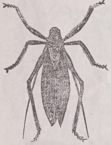
A large, green, arboreal, orthopterous insect (Cyrtophyllus concavus) of the family Locustidae, common in the United States. The males have stridulating organs at the bases of the front wings. During the summer and autumn, in the evening, the males make a peculiar, loud, shrill sound, resembling the combination Katy-did, whence the name.
KatÍf
Encyclopedia Britannica
KATÍF, or El Katif, a town of Arabia, in the maritime region which skirts the northern part of the Persian Gulf on the low muddy shore of the northmost of the secondary bays that break the outline of the Bay of Bahrein, in 26° 29' N. lat. and 50° E. long. Town and district are sometimes considered as part of El Hasa, sometimes as an independent province. The town lies embosomed amid luxuriant palm groves and gardens, but, according to Palgrave, is “crowded, damp, and dirty.” As the seaport of Nejd, it has a considerable trade. The principal building is the fortress or palace,—a strong and spacious structure, whose erection is popularly assigned to Abu Sa ’ id el Jannâby el Karmaty, the founder of the Karmathians. Katif was the chief seat of the Karmathian power. About the middle of the 18th century we find it, along with El Hasa, in the hands of Ibn Muflik, whose influence was paramount throughout Nejd. In 1791 it was captured by Sa'ùd, the leader of the Wahhâby revolution. In 1871 it was attacked, and according to their own account subjugated, by the Turks from Baghdad. The population of the town and district is given as from 90,000 to 100,000. Katif is not far from the probable site of the ancient Gerrha, which was inhabited by Chaldaean exiles from Babylon (Strabo, xvi. 766); in more modern times the population has been recruited from Persia.
See Captain G. F. Sadlier, in Trαηs. Lit. Sοc. Bombay, 1823; Pelly, in Joum. Roy. Geogr. Soc., 1865; Palgrave, Central and Eastern Arabia, 1873; Zehme, Arabien und die Araber, Halle, 1875.
9th ed. Encyclopædia Britannica, vol. 14, p. 15
[279 words — estimated reading time: 2 minutes]
[279 words — estimated reading time: 2 minutes]
KÁthiÁwÁr
Encyclopedia Britannica
KÁTHIÁWÁR, or Kattywar, also Surâshtra, a peninsula forming a collection of native states in Guzerat, western India, lying between 20° 41' and 23° 8' N. lat., and 68° 56' and 72° 20' E. long. It is bounded on the N. by the Runn or Gulf of Cutch, on the E. by Ahmedâbâd district and the Gulf of Cambay, and on the S. and W. by the Arabian Sea; the extreme length is 220 miles, the greatest breadth about 165 miles, the area about 22,000 square miles, and the estimated nonulation 2.500.000....
It is divided into one hundred and eighty-eight separate states, large and small, of which thirteen pay no tribute, ninety-six are tributary to the British Government, and seventy to the gâekwâr as the representative of the Marhattâs, while of these three classes of states one hundred and thirty-two pay a tax called zortalabi to the nawâb of Junâgarh. The states are arranged in seven classes: the chiefs of the first and second classes exercise plenary jurisdiction, both civil and criminal; the judicial powers of the lesser chiefs are graded in a diminishing scale, the residuary jurisdiction being vested in four British officers, each superintending a group of states. The political agent controls the whole. As a rule, no appeal lies from the decision of a chief; but on presumption of maladministration his proceedings may be called for and reviewed. During the past twenty years the states have established civil and criminal courts and written codes. Justice is administered by the political officers on the non-regulation system over 2058 square miles, or about one-tenth of the whole area. Outlawry, political and predatory, has been suppressed, and life and property are as safe as in British districts. A village police has been established, and municipal funds are voted by the states. In 1878 there were 488 schools, with 28,171 scholars; while at the Râjkumar College, and three high schools many of the chiefs receive a liberal education during their minority. There is railway communication with Wadhwân, and an extension is in progress to Dhorâji and Bhaunagar, while a network of good roads extend from Râjkot, the headquarters of the agency, over the greater part of the province. Kâthiâwâr is divided for administrative purposes into four prants or districts,—Jhalâwâr, Hâllâr, Sorâth, and Gohelwâr; but the old territorial prants are ten, viz., Jhalâwâr in the north, containing about fifty states; Machhukântâ; Hâllâr, with twenty-sixty states; Okhamandal, belonging to Baroda; Baradâ or Jaitwâr, also known as Porbandar; Sorâth; Babriâwâr; Kâthiâwâr; Und-Sarviya; and Gohelwâr. The last-named comprises the Gogo district, belonging to the Ahmedâbâd collectorate; Bhaunagar, probably the foremost state in Kâthiâwâr; and many others.
Generally speaking, the surface of the country is undulating, with low ranges running in very irregular directions; with the exception of the Tânghâ and Mândhav hills, in the west of Jhalâwâr, and some unimportant hills in Hâllâr, the northern portion of the country is flat; but in the south, from near Gogo, the Gir range runs nearly parallel with the coast, and at a distance of about 20 miles from it, along the north of Babriâwâr and Sorâth, to the neighbourhood of Gïrnâr. Opposite this latter mountain is the solitary 0sam hill, and then still farther west is the Baradâ group, between Hâllâr and Baradâ, running about 20 miles north and south from Gumti to Rânâwan. The Girnâr clump of mountains is an important granitic mass, the highest peak of which rises to 3500 feet. The principal river is the Bhâdar, which rises in the Mândhav hills, and flowing south-west falls into the sea at Navi-Bandar, in Baradâ; it is everywhere marked by highly cultivated lands adjoining its course of about 115 miles. Other rivers are the Aji, Machhu, and Satπinji—the last remarkable for wild and romantic scenery. Four of the old races, the Jâitwas, Churâsamas, Solunkis, and Wâlâs are now existing as proprietors of the soil who exercised sovereignty in the country prior to the immigration of the Jhalâs, Jârejas, Purmars, Kathis, Gohels, Jâts, Mohammedans, and Marhattâs, between whom the country is now chiefly portioned out.
The principal agricultural products consist of cotton, bàjrd, and jοdr, and in some parts sugar-cane, turmeric, and indigo. Horse and sheep breeding is carried on to a great extent—these animals, together with food grains, rawcotton,and wool, forming the chief exports. The principal imports are cotton manufactures, metals, and sugar. Iron is found in many parts of Barada and Hâllâr. Many iron-mines have, however, had to be abandoned of late years owing to the scarcity of fuel for smelting the ore. The principal towns are Jamnagar, Bhaunagar, Junâgarh, Rajkot, Porbandar, and Mangrol. The last two, as also Verâwal, are thriving seaport towns. Kâthiâwâr has many notable antiquities, comprising rock inscriptions of Asoka, Buddhist caves, and. fine Jain temples on the sacred hill of Girnâr, and at Pâlitana.
9th ed. Encyclopædia Britannica, vol. 14, p. 14
[903 words — estimated reading time: 6 minutes]
[903 words — estimated reading time: 6 minutes]
No thesaurus entries found for "Kat".
King James Bible KJV Bible
Berean Standard Bible BSB Bible
1 KJV and 2 BSB verses contain “Kat”
Even these of them ye may eat; the locust after his kind, and the bald locust after his kind, and the beetle after his kind, and the grasshopper after his kind.