
A variety of carnelian, of a rich reddish yellow or brownish red color. See the Note under Chalcedony.
Word of the Day: Catachrestical
Sardanapalus
Encyclopedia Britannica
SARDANAPALUS was, according to the account of Ctesias (preserved by Diodorus, 23 sq.), the last king of Nineveh, and he is described in terms that have made his name proverbial as the type of splendid and luxurious effeminacy. Ctesias’s story cannot be called historical; but the name Sardanapalus seems to be a corruption of Assurbanipal (see vol. iii. p. 188).
9th ed. Encyclopædia Britannica, vol. 21, p. 307
[61 words — estimated reading time: 1 minute]
[61 words — estimated reading time: 1 minute]
1. S'ARDE ,
2. S'ARDE L,
3. S'ARDINE,
4. S'ARDIUS, noun [Latin sardius; Gr. from Sardis, in Asia Minor, now Sart.] A precious stone. One of this kind was set in Aaron's breastplate. Exodus 28:1 .
1. Any one of several small species of herring which are commonly preserved in olive oil for food, especially the pilchard, or European sardine (Clupea pilchardus). The California sardine (Clupea sagax) is similar. The American sardines of the Atlantic coast are mostly the young of the common herring and of the menhaden.
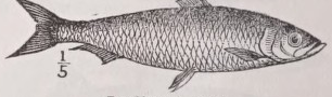
2. See Sardius.
Sardine
Encyclopedia Britannica
SARDINE (Clupea pilchardus ). See Pilchard . Another of the Clupeidae (G. scombrina) is the “oil-sardine” of the eastern coast of the Indian Peninsula.
9th ed. Encyclopædia Britannica, vol. 21, p. 307
[23 words — estimated reading time: 1 minute]
[23 words — estimated reading time: 1 minute]
Sardinia
Encyclopedia Britannica
SARDINIA (Ital. Sardegna, Fr. Sardaigne, Span. Cerdeña, called by the ancient Greeks 'Ιχνούσα, from a fancied resemblance to the print of a foot), an island in the Mediterranean, about 140 miles from the west coast of Italy, of which kingdom it forms a part. It is separated from the island of Corsica by the Strait of Bonifacio, which is about 7½ miles wide, and only about 50 fathoms deep. Sardinia lies between 8° 4' and 9° 49' E. long., and extends from 38° 55' to 41° 16' N. lat. The length from Cape Teulada in the south-west to Cape Longo Sardo in the north is about 160 miles, the breadth from Cape Comino to Cape Caccia about 68 miles. The area of the island is 9187 square miles,—that of the department (compartimento), including the small islands adjacent, being 9294 square miles. It ranks sixth in point of size among the islands of Europe, coming next after Sicily....
The greater part of the island is mountainous, especially in the east, where the mountains stretch almost continuously from north to south, and advance close up to the coast. The elevations, however, are not so high as in the sister island of Corsica. The culminating point is Monte Gennargentu, which rises, about 22 miles from the east coast, almost exactly on the parallel of 40° N., to the height of 6250 feet, and is consequently little more than two-thirds of the height of the chief peaks of Corsica. On the east side the principal breach in the continuity of the mountains occurs in the north, where a narrow valley opening to the east at the Gulf of Terranova cuts off the mountains of Limpara in the extreme north-east. The western half of the island has more level land. The principal plain, that of the Campidano, stretches from southeast to north-west, between the Gulf of Cagliari and that of Oristano, and nowhere attains a greater elevation than 250 feet. At both ends it sinks to a much lower level, and has a number of shallow lagoons encroaching on it from the sea. In the corner of the island situated to the south-west of the Campidano there are two small isolated mountains rising to the height of from 3000 to 4000 feet, which are of importance as containing the chief mineral wealth of the island. A small valley runs between them from the southern end of the Campidano to Iglesias, the mining centre of Sardinia. North of the Gulf of Oristano mountains again appear. The extinct volcano of Monte Ferru there rises to the height of 4400 feet, and the streams of basalt which have issued from it in former ages form the ridge or saddle, about 2000 feet high, connecting this mountain with the highland area on the east. Still further north a trachytic plateau, intersected by numerous deep river valleys, occupies a considerable tract, advancing up to the plain of Sassari on the north coast.
The rivers are numerous but short. The principal is the Oristano, which enters the gulf of the same name on the west coast.
Geologically the island is composed mainly of granite and other crystalline rocks. Granite predominates especially in the east, and the mountains of that part of the island were apparently at one time continuous with the similarly constituted mountains of Corsica. Granitic spurs likewise extend to the south-west, and appear in the capes of Spartivento and Teulada. Altogether this rock is estimated to cover one-half of the entire surface. In the west of the island the principal crystalline rocks are porphyritic in structure; sedimentary deposits are comparatively unimportant, and such as are present are mainly cither of very ancient or of recent geological date. Silurian formations attain their most considerable development in the south-west round Iglesias, where there occurred the contemporaneous porphyritic outpourings containing the most numerous mineral veins of the island. Between the deposits of Silurian and those of Cretaceous times there are none of any consequence except a few patches of Devonian round the slopes of Gennargentu, interesting as containing some beds of true coal. The members of the Cretaceous system occupy considerable tracts in the southwest, east (round the Gulf of Orosei), and north-west (in the mountains of Nurra), and a smaller area in the southwest (in the island of San Antioco). Tertiary formations are still more largely developed. They cover the whole plain of the Campidano, the west coast opposite the island of San Antioco, and the narrow valley in the north-east already mentioned. The basalts of Monte Ferru are also of Tertiary date, and it does not appear to have been till that epoch that Sardinia formed a single island.
In variety of mineral wealth the southern half of Sardinia is the richest province of Italy, and it stands second in the annual value of its mineral products. The chief minerals are sulphates of lead more or less argentiferous (galena), sulphates and silicates of zinc, ordinary iron pyrites, sulphates of iron and copper, of antimony, and of arsenic, besides cobalt, nickel, and silver. The coal on the flanks of Gennargentu is of good enough quality to furnish a valuable fuel, and is found in sufficiently thick seams to be workable if only the means of transport were present, but its situation is such as to render it of no economical importance. In the Tertiary deposits of the south-west there are some veins of manganese ore, and also some beds of lignite which are worked as a source of fuel for local use. The mineral wealth of Sardinia was known in ancient times, and mines were worked both by the Carthaginians and the Romans. During the Middle Ages they were for the most part neglected, but the industry was revived in modern times, and has been greatly developed in recent years. Upwards of 70 mines have now been opened, most of them in the district of which Iglesias is the centre, but a few near the southern part of the east coast, where Muravera is the chief town. The mines are mostly of argentiferous lead, silver, zinc, and iron. The ores are mainly exported in the raw state, only the inferior sorts being smelted in the island. Among other mineral products are building stones (granite, marble, &c.), alabaster, and salt.
The climate of Sardinia is similar to that of the rest of the Mediterranean region, and the southern half of the island shares in the nearly rainless summers characteristic of the southern portions of the Mediterranean peninsulas. At Cagliari there are on an average only seven days on which rain falls during June, July, and August. Throughout the island these months are the driest in the year, and hence vegetation on the lower ground at least is generally at a standstill during that period, and shrubs with broad leathery leaves fitted to withstand the drought (the so-called maquis) are as characteristic here as in Corsica and on the mainland. Winter is the rainiest season of the year; but the heat and drought of summer (mean temperature 95° F.) make that the most unpleasant of the seasons, while in the low grounds the prevalence of malaria renders it a most unhealthy one, especially for visitors. Autumn, which is prolonged into December, is the most agreeable season; there is then neither heat nor cold, nor mist nor fever, and at that period birds of passage begin to immigrate in large numbers.
The agricultural products of the island are greatly inferior to what might be expected in view of the natural fertility of the soil. Two causes are assigned for this. The first is the minute subdivision of the land, which, as in Corsica, is carried to such an extent that where an owner has as much as 100 acres his property is divided into 25 or 30 lots surrounded by parcels of land belonging to other owners. In such circumstances it is neither possible to apply adequate capital to the cultivation of the ground, nor for the owners to acquire the requisite capital. The second cause is the malaria which renders certain districts possessed of a fertile soil quite uninhabitable; and this second cause can be remedied only when a remedy has been found for the first, for, as the malaria is undoubtedly one cause of diminished cultivation, it is equally certain that want of cultivation is one of the causes of the malaria. In ancient times Sardinia was one of the granaries of Rome; now cereals take a comparatively unimportant place among the exports, and this export is balanced by a considerable import of the same commodity. The chief products of agriculture are wheat, barley, and beans, the last furnishing an important element of the food of the people, olives run wild in many places, and are grown in sufficient abundance to meet the local demand. Almonds, oranges, and citrons are also largely cultivated, and the oranges of San Vito, near Muravera, and of Milis, a few miles to the north of Oristano, are noted for their excellence; the white wines of the banks of the Oristano are of good repute; and among other products of the island are mulberries, tobacco, madder, anil hemp. Forests of oak, cork-oak, firs, and pines, though greatly reduced in extent, still cover, it is said, about one-fifth of the surface. The rearing of live-stock receives more attention than agriculture proper. No artificial pasture-grasses are grown, but the natural pastures beside the numerous rivers yield abundance of food, except during the dry season, when the horses, asses, cattle, sheep, and goats have to content themselves with straw, some dried beans, and a little barley. Most attention is bestowed on horses. At one time the Sardinian Government endeavoured to keep a stud on the island for rearing horses for the Piedmontese cavalry, but the persons employed (natives of the mainland) were unable to withstand the malaria. There are some large private establishments for the rearing of horses, however, and the tending of live-stock generally forms so important a part of the occupations of the people that animals rank next after minerals among the exports of the island. Of the wild animals, the wild sheep known as the musimon, or European mutllon, formerly an inhabitant of all the mountains of the Mediterranean peninsulas and islands, and now confined to Sardinia and Corsica, is the most interesting. Among the noxious animals are scorpions and tarantulas.
The lagoons near the coast on the south and west abound in mullets, eels, mussels, and crabs, which are caught in great numbers by the natives, while the fisheries round Sardinia, as round Corsica, are in the hands of Italians from the mainland. The anchovy, sardine, and coral fisheries are all lucrative. The coral is said to be of excellent quality, and is exported to the markets of Genoa and Marseilles.
The external commerce of the island has nearly trebled itself in the twenty-five years 1856-81, the imports and exports each amounting in the latter year to about £1,500,000 (about £2, 4s. per head of population). This increase is chiefly owing to the development of the mining industry, ores making up nearly one-third of the total value of the exports. Live animals make up about a fourth of the total value, and cereals, which come next in order, about one-seventh. The chief imports are cotton and other manufactures and colonial products. The inland trade has been greatly promoted within the last fifty years by the construction of roads and railways. Before 1828 there were no roads at all in the island; the tracks which existed could be traversed only on foot or on horseback. But upwards of 1500 miles of national and provincial roads, all well made and well kept, have since then been constructed. Of railways, introduced since 1870, there are now 265 miles in all (equal to about 1 mile of railway for every 34 square miles of surface).
For administrative purposes Sardinia, like the rest of Italy, is divided into provinces and circles (circondarii'). The following table gives the names of these divisions with the population according to the last census (end of 1881) :— [table]
The whole population of the department is thus 682,002, equal to about 74 to the square mile, Sardinia being the least populous of all the great divisions of the kingdom, in which the average density is 255 to the square mile. The population is, however, increasing at a rather more rapid rate than on the mainland. Between 1871 and 1881 it increased by about 46,000, or 7.18 per cent., while the average rate of increase throughout the kingdom was only 6·16 per cent.
The inhabitants of Sardinia are a hardy race, of about middle height, and of dark complexion. They are little accustomed to hard work, but this is one of the consequences of the backward state of their civilization and of the impediments already indicated to the development of the resources of the island. Education, as in many other parts of Italy, is very far behind, notwithstanding the law which makes elementary education compulsory; but here, as throughout the kingdom, it is rapidly extending. In 1880-81 only 37,197 children, or less than one-eighteenth of the population, were in attendance at the elementary schools, but this number was double what it had been in 1861-62. At Cagliari there is a university, attended by from 300 to 400 students.
The people are lively in their disposition, fond of music and poetry, remarkably hospitable, and strong in their family attachments. With this last trait, however, is connected the chief blot on their character—their addiction to the practice of the vendetta, which prevails here as in Corsica, and according to which an outrage on one’s honour is wiped out in blood, and the cause of one member of a family is taken up by the rest, so that the death of one victim leads to the sacrifice of many others. But the practice is said to be becoming every day more rare, and never to be resorted to except in case of serious offence.
The capital of the island is Cagliari, but Sassari in the north has an equally large population (about 34,000). The other chief towns are Tempio, Algliero, Iglesias, and oristano. Cagliari, Alghero, and Castel Sardo are fortified.
The antiquities of the island are numerous and of peculiar interest. The most remarkable of these are the monuments called nurhags (variously spelled also nuraghc, mcraghi, &c.), of which there are upwards of 3000 scattered over the island. They are round structures having the form of truncated cones, and are generally built of the hardest materials the island supplies (granite, basalt, trachyte, limestone, &c.). The stone is roughly hewn into large blocks, which are laid in regular horizontal courses but not cemented. The blocks in the lower courses are sometimes more than three feet in length. Entrance is obtained by a very low opening at the base to an inner chamber; and, when there are two or, as in some cases, three stories, these are connected by means of a spiral staircase. The origin and use of these structures are both matters of speculation. The rarity of human remains in them is against the idea that they were used as tombs, while the absence of any relics pertaining to a religious ceremonial is equally adverse to the supposition that they were used as temples. Next to the nurhags the most interesting of the remains of antiquity are tho so-called tombs of the giants, which appear to have been actually used as places of burial, although, as the name given to them indicates, their dimensions are greatly in excess of those of the human body. Besides these there are tombs the structure of which leads to the belief that they must be relics of an Egyptian colony.
History.— According to Prof. Crespi, of the university of Cagliari, the tombs just referred to are not the only signs of an early Egyptian settlement in the island of Sardinia. Various remains are said to prove beyond doubt that Egyptians must have founded at least two colonies in very remote times—one at tho ancient town of Tharrus on the small peninsula of San Marco at the northern extremity of the Gulf of Oristano, and the other at Caralis, the present Cagliari. But even before the Egyptians Prof. Crespi believes that the Phoenicians had established a colony on the small island of San Antioco, and had built there the town of Sulcis, the ruins of which are still to be seen near the town of San Antioco. Of Phoenicians and Egyptians, however, there are no trustworthy historical records, and the first settlers whose arrival is historically accredited were the Carthaginians, who succeeded in making themselves masters of the island under Hasdrubal in 512 b.c . The island remained in Carthaginian hands for upwards of two hundred and seventy years, and then passed into those of tho Romans, who took advantage of the war in which Carthage was involved with her mercenary troops after the close of the First Punic War to seize the island (238 b.c.). Thenceforward the island remained in possession of the Romans till near the fall of the empire of the West, when Sardinia also began to suffer from the ravages of the northern hordes by which Italy was at that time overrun and the empire of the West overthrown. About the middle of the 5th century the island was occupied by the Vandals under Genseric, but in the first half of the following century these were expelled by Belisarius. Very soon after, however, Goths succeeded the Vandals, and after these had in their turn been driven out by Narses the natives managed to expel the Romans and to achieve their independence (665). The Sardinians thereupon elected the leader in the revolt against Rome king of the island, and by 7 him the island was divided into the four grand-judicatures of Cagliari, Arborea, Torres, and Gallura. The grand-justices or rulers of these four divisions continued to retain a considerable amount of power during a large part of the Middle Ages. But from the early part of the 8th century down to the middle of the 11th their influence was greatly impaired by repeated inroads of the Saracens, who landed now on one coast now on another, and kept the inhabitants in a constant state of alarm. This state of matters was at last put an end to by the Genoese and Pisans, who, acting under the sanction of the pope, despatched a fleet against that of the Saracens. A battle ensued in the Bay of Cagliari; the Saracens were completely defeated, and the allies landed on the island (1050). Very soon the Pisans adroitly managed to rid themselves of the Genoese, and to gain possession of almost the entire island, deposing the grand-justices of Cagliari, Torres, and Gallura. With the Pisans the greater part of the island remained till 1325, when the pope gave Sardinia to the king of Aragon, who combined with the grand-justice of Arborea to drive out the former rulers. But, this being accomplished, war soon broke out between the two, and numerous successes were gained by the grand-justice Marian IV. and his daughter Eleonora acting as regent on behalf of her son Marian V., a minor. The Aragonese seemed to be on the point of being driven out of the island when Eleonora died of the plague (1403), and soon after the whole island became an Aragonese (after the union of the crowns of Aragon and Castile a Spanish) province. It remained Spanish till the treaty of Utrecht in 1713, when it was ceded to the house of Austria, by which in 1720 it was handed over to Victor Amadeus II., duke of Savoy, in exchange for the island of Sicily. Shortly before the date of this acquisition the duke of Savoy (see Savoy) had had the title of king conferred upon him, and when the cession of Sardinia took place the title was changed to that of king of Sardinia. With this kingdom the island ultimately became merged in the kingdom of Italy.
See La Marmora, Voyage en Saedaigne (Paris, 2d ed., 1837-57); Roissard do Belief, La Sardaigne a col doiseau (Paris, 1884); Robert Tennant, Sardinia and its Resources (Loud., 1885).
9th ed. Encyclopædia Britannica, vol. 21, p. 307 — signed G. G. C.
[3,427 words — estimated reading time: 20 minutes]
[3,427 words — estimated reading time: 20 minutes]
Of or pertaining to the island, kingdom, or people of Sardinia.
Sardis
Encyclopedia Britannica
SARDIS (οί Σάρςϵις), the capital of the kingdom of Lydia, the seat of a conventus under the Roman empire, and the metropolis of the province Lydia in later Roman and Byzantine times, was situated in the middle Hermus valley, at the foot of Mount Tmolus, a steep and lofty spur of which formed the citadel. It was about 20 stadia (2½ miles) south of the Hermus. The earliest reference to Sardis is in the Persae of AEschylus (472 b.c. ); in the Iliad the name Hyde seems to be given to the city of the Maeonian (i.e ., Lydian) chiefs, and in later times Hyde was said to be the older name of Sardis, or the name of its citadel. It is, however, more probable that Sardis was not the original capital of the Maeonians, but that it became so amid the changes which produced a powerful Lydian empire in the 8th century b.c. The city, but not the citadel, was destroyed by the Cimmerians in the 7th century, by the Athenians in the 6th, and by Antiochus the Great in the 3d century; once at least, under the emperor Tiberius, it was destroyed by an earthquake; but it was always rebuilt, and continued to be one of the great cities of western Asia Minor till the later Byzantine time. Its importance was due, first to its military strength, secondly to its situation on an important highway leading from the interior to the AEgean coast, and thirdly to its commanding the wide and fertile plain of the Hermus. The early Lydian kingdom was far advanced in the industrial arts (see Lydia), and Sardis was the chief seat of its manufactures. The most important of these trades was the manufacture and dyeing of delicate woollen stuffs and carpets. The statement that the little stream Pactolus which flowed through the market-place rolled over golden sands is probably little more than a metaphor, ...due to the wealth of the city to which the Greeks of the 6th century b.c. resorted for supplies of gold; but trade and the practical organization of commerce were the real sources of this wealth. After Constantinople became the capital of the East a new road system grew up connecting the provinces with the capital. Sardis then lay rather apart from the great lines of communication and lost some of its importance. It still, however, retained its titular supremacy, and continued to be the seat of the metropolitan bishop of the province. It is enumerated as third, after Ephesus and Smyrna, in the list of cities of the Thracesian thema given by Constantine Porphyrogenitus in the 10th century; but in the actual history of the next four centuries it plays a part very inferior to Magnesia ad Sipylum and Philadelphia, which have to the present day retained their pre-eminence in the district. The Hermus valley began to suffer from the inroads of the Seljuk Turks about the end of the 11th century; but the successes of the Greek general Philocales in 1118 relieved the district for the time, and the ability of the Comneni, together with the gradual decay of the Seljuk power, retained it in the Byzantine dominions. The country round Sardis was frequently ravaged both by Christians and by Greeks during the 13th century. Soon after 1301 the Seljuk emirs overran the whole of the Hermus and Cayster valleys, and a fort on the citadel of Sardis was handed over to them by treaty. Finally in 1390 Philadelphia, which had for some time been an independent Christian city, surrendered to Sultan Bayazid’s mixed army of Ottoman Turks and Byzantine Christians, and the Seljuk power in the Hermus valley was merged in the Ottoman empire. The latest reference to the city of Sardis relates its capture (and probable destruction) by Timur in 1402. Its site is now absolutely deserted, except that a tiny village, Sart, merely a few huts inhabited by semi-nomadic Yuruks, exists beside the Pactolus, and that there is a station of the Smyrna and Cassaba Railway a mile north of the principal ruins.
The ruins of Sardis, so far as they are now visible, are chiefly of the Roman time; but probably few ancient sites would more richly reward the excavator with remains of all periods from the early pre-Hellenic time downwards. O11 the banks of the Pactolus two columns of a temple of the Greek period, probably the great temple of Cybele, are still standing. More than one attempt to excavate this temple, the last by Mr G. Dennis in 1882, have been made and prematurely brought to an end by lack of funds. The necropolis of the old Lydian city, a vast series of mounds, some of enormous size, lies on the north side of the Hermus, four or five miles from Sardis, a little south of the sacred lake Coloe; here the Maeonian chiefs, sons, according to Homer, of the lake, were brought to sleep beside their mother. The series of mounds is now called Bin Tepe (Thousand Mounds). Several of them have been opened by modern excavators, but in every case it was found that treasure-seekers of an earlier time had removed any articles of value that had been deposited in the sepulchral chambers.
9th ed. Encyclopædia Britannica, vol. 21, p. 310
[879 words — estimated reading time: 6 minutes]
[879 words — estimated reading time: 6 minutes]
Sardis
Watson's Biblical & Theological Dictionary
a city of Asia Minor, and formerly the capital of Crœsus, king of the Lydians. The church of Sardis was one of the seven churches of Asia, to which the writer of the Apocalypse was directed to send an epistle, Rev. iii, 1–3.
Watson's Biblical & Theological Dictionary
[43 words — estimated reading time: 1 minute]
[43 words — estimated reading time: 1 minute]
A precious stone, probably a carnelian, one of which was set in Aaron's breastplate.
Sardius
Watson's Biblical & Theological Dictionary
אדם, so called from its redness, Exod. xxviii, 17; xxxix, 10; Ezek. xxviii, 13; σάρδιος, Rev. xxi, 20; a precious stone of a blood-red colour. It took its Greek name from Sardis, where the best of them were found.
Watson's Biblical & Theological Dictionary
[39 words — estimated reading time: 1 minute]
[39 words — estimated reading time: 1 minute]
A mineral, a variety of carnelian, which displays on its surface a rich reddish brown, but when held between the eye and the light, appears of a deep blood red.
1. SARDO'NIAN ,
2. SARDON'IC, adjective sardonian or sardonic laughter, a convulsive involuntary laughter, so called from the herba sardonia, a species of ranunculus, which is said to produce such convulsive motions in the cheeks and lips as are observed during a fit of laughter.
1. Forced; unnatural; insincere; hence, derisive, mocking, malignant, or bitterly sarcastic; -- applied only to a laugh, smile, or some facial semblance of gayety.
2. Of, pertaining to, or resembling, a kind of linen made at Colchis.
A silicious stone or gem, nearly allied to carnelian. Its color is a reddish yellow, or nearly orange. We are informed that the yellow or orange colored agate, with an undulating surface, is now often called sardonyx
Sardonyx
Encyclopedia Britannica
SARDONYX, a name applied to those varieties of onyx, or stratified chalcedony, which exhibit white layers alternating with others of red or brown colour. The brown chalcedony is known to modern mineralogists as sard and the red as camelian. The simplest and commonest type of sardonyx contains two strata,—a thin layer of white chalcedony resting upon a ground of either carnelian or sard; but the sardonyx of ancient writers generally presented three layers—a superficial stratum of red, an intermediate band of white, and a base of dark brown chalcedony. The sardonyx has always been a favourite stone with the cameo-engraver, and the finest works have usually been executed on stones of five strata. Such, for instance, is the famous Carpegna cameo, in the Vatican, representing the triumph of Bacchus and Ceres, and reputed to be the largest work of its kind ever executed (16 inches by 12). When the component layers of a sardonyx are of fine colour and sharply defined, the stone is known in trade as an “Oriental sardonyx”—a term which is used without reference to the geographical source whence the stone is obtained. A famous ancient locality for sard was in Babylonia, and the name of the stone appears to be connected with the Persian word sered, “yellowish red,” in allusion to the colour of the sard. Pliny, relying on a superficial resemblance, derives the name from Sardis, reputed to be its original locality. The sardonyx is frequently stained, or at least its colour heightened, by chemical processes. Imitations are fabricated by cementing two or three layers of chalcedony together, and so building up a sardonyx; while baser counterfeits are formed simply of paste. See Onyx, vol. xvii. p. 776.
9th ed. Encyclopædia Britannica, vol. 21, p. 310
[287 words — estimated reading time: 2 minutes]
[287 words — estimated reading time: 2 minutes]
Sardonyx
Watson's Biblical & Theological Dictionary
σαρδόνυξ, Rev. xxi, 20. A precious stone which seems to have its name from its resemblance partly to the sardius and partly to the onyx. It is generally tinged with black and blood colour, which are distinguished from each other by circles or rows, so distinct that they appear to be the effect of art.
Watson's Biblical & Theological Dictionary
[55 words — estimated reading time: 1 minute]
[55 words — estimated reading time: 1 minute]
Jewelry Roget’s Thesaurus §847a
N. jewel, jewelry, jewellery, bijoutry|, bijou, bijouterie, trinket, fine jewelry, costume jewelry, junk jewelry, gem, gemstone, precious stone, necklace, bracelet, anklet, earring, locket, pendant, charm bracelet, ring, pinky ring, carcanet, chain, chatelaine, broach, pin, lapel pin, torque, diamond, brilliant, rock, beryl, emerald, chalcedony, agate, heliotrope, girasol, girasole, onyx, plasma, sard, sardonyx, garnet, lapis lazuli, opal, peridot, tourmaline, chrysolite, sapphire, ruby, synthetic ruby, spinel, spinelle, balais, oriental, oriental topaz, turquois, turquoise, zircon, cubic zirconia, jacinth, hyacinth, carbuncle, amethyst, alexandrite, cat's eye, bloodstone, hematite, jasper, moonstone, sunstone, pearl, cultured pearl, fresh-water pearl, mother of pearl, coral, jeweler, gemologist, minerologist, lapidary, lapidarian, gemology, gemmology, minerology
V. shine like a diamond
King James Bible KJV Bible
Berean Standard Bible BSB Bible
10 KJV and 4 BSB verses contain “sard”
Of the sons of Zebulun after their families: of Sered, the family of the Sardites: of Elon, the family of the Elonites: of Jahleel, the family of the Jahleelites.
These were the descendants of Zebulun by their clans: The Seredite clan from Sered, the Elonite clan from Elon, and the Jahleelite clan from Jahleel.
Thou hast been in Eden the garden of God; every precious stone was thy covering, the sardius, topaz, and the diamond, the beryl, the onyx, and the jasper, the sapphire, the emerald, and the carbuncle, and gold: the workmanship of thy tabrets and of thy pipes was prepared in thee in the day that thou wast created.
And unto the angel of the church in Sardis write; These things saith he that hath the seven Spirits of God, and the seven stars; I know thy works, that thou hast a name that thou livest, and art dead.
“To the angel of the church in Sardis write: These are the words of the One who holds the seven Spirits of God and the seven stars. I know your deeds; you have a reputation for being alive, yet you are dead.
The fifth, sardonyx; the sixth, sardius; the seventh, chrysolite; the eighth, beryl; the ninth, a topaz; the tenth, a chrysoprasus; the eleventh, a jacinth; the twelfth, an amethyst.
the fifth sardonyx, the sixth carnelian, the seventh chrysolite, the eighth beryl, the ninth topaz, the tenth chrysoprase, the eleventh jacinth, and the twelfth amethyst.
And of the sons of Zamoth; Eliadas, Elisimus, Othonias, Jarimoth, and Sabatus, and Sardeus.