
Alt. of Bunn
Word of the Day: Catachrestical
2. A cluster; a number of the same kind growing together; as a bunch of grapes.
3. A number of things tied together; as a bunch of keys; a bunch or rods.
4. A collection of things; a knot; as a bunch of hair; a bunch of trees.
To swell out in a protuberance; to be protuberant or round.
2. A collection, cluster, or tuft, properly of things of the same kind, growing or fastened together; as, a bunch of grapes; a bunch of keys.
3. A small isolated mass of ore, as distinguished from a continuous vein.
To swell out into a bunch or protuberance; to be protuberant or round.
To form into a bunch or bunches.
Bunch grass
Webster's Dictionary 1913
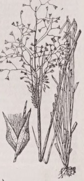
A grass growing in bunches and affording pasture. In California, Atropis tenuifolia, Festuca scabrella, and several kinds of Stipa are favorite bunch grasses. In Utah, Eriocoma cuspidata is a good bunch grass.
The quality of being bunchy, or growing in bunches.
The quality or condition of being bunchy; knobbiness.
1. Swelling out in bunches.
2. Growing in bunches, or resembling a bunch; having tufts; as, the bird's bunchy tail.
3. Yielding irregularly; sometimes rich, sometimes poor; as, a bunchy mine.
1. League; confederacy; esp. the confederation of German states.
2. An embankment against inundation.
Bundelkhand
Encyclopedia Britannica
BUNDELKHAND, an extensive tract, consisting partly of British districts and partly of native states, in the NorthWestern Provinces of India, lying between 23° 52' and 26° 26' N. lat., and 77° 53' and 81° 39' E. long. It is bounded on the N. by the Jumna, on the E. by the Bághalkhand or the Rewá state, on the S. by the Central Provinces, and the W. by the state of Gwalior.
It comprises the British districts of Hamírpur, Jalaun, Jhánsi, Lalatpur, and Bándá; the semi-independent states of Orchhá or Tehrí, Datiyá, and Samthar; and the following petty states held under grants from the British Government, viz.:—Ajegarh, Alípurá, Ashtgarhí Jágír, Tori-Fathpur, Bijná and Pahárí Banká, Bárondá, Báwaní, Berí, Bíhat, Bijáwar, Charkhárí, seven Chaubiyáná Kalinjár Jágírs, Chhatrapur, Garraulí, Gáuríhar, Jasú, Jigní, Khaniyá Dháná, Lughásí, Naigáon Ribahí, Panná, and Sarilá. Length of Bundelkhand—200 miles from S.E. to N.W.; breadth, 155 miles; area variously estimated from 18,099 to 23,817 square miles....
The surface of the country is uneven and hilly, except in the N.E. part, which forms an irregular plain cut up by ravines scooped out by torrents during the periodical rains. The plains of Bundelkhand are intersected by three mountain ranges, the Bindháchal, Panná, and Bander chains, the highest elevation not exceeding 2000 feet above sea-level. Beyond these ranges the country is further diversified by isolated hills rising abruptly from a common level, and presenting from their steep and nearly inaccessible scarps eligible sites for castles and strongholds, whence the mountaineers of Bundelkhand have frequently set at defiance the most powerful of the native states of India. The general slope of the country is towards the north-east, as indicated by the course of the rivers which traverse or bound the territory, and finally discharge themselves into the Jumna.
The principal rivers are the Sindh, Betwá, Ken, Baighin, Paisuní, Tons, Pahuj, Dhasán, Bermá, Urmal, and Chandra-wál. The Sindh, rising near Sironj in Málwa, marks the frontier line of Bundelkhand on the side of Gwalior. Parallel to this river, but more to the eastward, is the course of the Betwá. Still further to the east flows the Ken, followed in succession by the Baighin, Paisuní, and Tons. The Jumna and the Ken are the only two navigable rivers. Notwithstanding the large number of streams, the depression of their channels and height of their banks render them for the most part unsuitable for the purposes of irrigation,—which is conducted by means of jhils and tanks. These artificial lakes are usually formed by throwing embankments across the lower extremities of valleys, and thus arresting and accumulating the waters flowing through them. Some of the tanks are of great capacity: the Barwá Ságar, for instance, is 2½ miles in diameter. Diamonds are found, particularly near the town of Panná, in a range of hills called by the natives Band-Ahil.
The mines of Mahárájpur, Rájpur, Kimerá, and Gadásiá contain the finest diamonds; one dug from the last is reputed to be the largest in the world. It was kept in the fort of Kalinjas among the treasures of Rájá Himmat Bahádur. In the reign of the Emperor Akbar the mines of Panná produced diamonds to the amount of £100,000 annually, and were a considerable source of revenue, but for many years they have not been so profitable.
The tree vegetation consists rather of jungle or copse than forest, abounding in game which is preserved by the native chiefs. There are also within these coverts several varieties of wild animals, such as the tiger, leopard, hyena, Wild boar, nilg á i, and jackal.
British Bundelkhand contains a population of 2,161,495 souls. The total population of Bundelkhand, British and native, has been estimated at 2,260,714. The people represent various races. The Bundelâs,—the race who gave the name to the country,—still maintain their dignity as chieftains, by disdaining to cultivate the soil, although by no means conspicuous for lofty sentiments of honour or morality. An Indian proverb avers that “one native of Bundelkhand commits as much fraud as a hundred Dandis” (weighers of grain, and notorious rogues). About Datiyá and Jhánsi the inhabitants are a stout and handsome race of men, well off and contented.
The prevailing religion in Bundelkhand is Hinduism.
The principal crops are wheat, jo á r, cotton, indigo, sugarcane, a red dye called á ch, various kinds of millets and pulses, and mahu á (Bassia latifolia). Carpets are manufactured at Jhánsí, and paper at Kalpi. Bamboo and Acacia catechu from the jungles form important articles of trade. Principal routes—(1), from Allahábád to Nasirábád through Bándá; (2), from Fathipur to Ságar through Bándá; (3), from Cawnpur to Jabalpur; (4), from Cawnpur to Guná through Kálpí and Jhánsí; (5), from Bándá to Gwalior; and (6) from Agra to Ságar. The Jabalpur line of the East Indian Railway passes through the native states of Bundelkhand. Principal towns,—Kálpí, Bándá, Jhánsi, Datiyá, Urchá, Jalaun, Chhatrapur, Mahobá, and Tehárí. The climate of Bundelkhand is sultry and unhealthy.
History. —Chandra Varma, chief of the Chandel R á jputs, appears to have established the earliest paramount power in Bundelkhand towards the close of the 9th century a.d. Under his dynasty the country attained its greatest splendour in the early part of the 11th century, when its R á j á, whose dominions extended from the Jumna to the Nerbudda, marched at the head of 36,000 horse and 45,000 foot, with 640 elephants, to oppose the invasion of Mahmud of Ghazni. In 1183 the Chandel dynasty was overthrown by Pirthwi R á j, the ruler of Ajmir and Delhi, after which the country remained in ruinous anarchy until the close of the 14th century, when the Bundel á s, a spurious offshoot of the Garhw á tribe of Rajputs, established themselves on the right bank of the Jumna. One of these took possession of Urch á by treacherously poisoning its chief. His successor succeeded in further aggrandizing the Bundel á state, but he is represented to have been a notorious plunderer, and his character is further stained by the assassination of the celebrated Abulfazl, the prime minister and historian of Akbar. Jajhar Sinh, the third Bundel á chief, unsuccessfully revolted against the court of Delhi, and his country became incorporated for a short time with the empire. The struggles of the Bundel á s for independence resulted in the withdrawal of the royal troops, and the admission of several petty states as feudatories of the empire on condition of military service. The Bundel á s, under Champat Râi and his son Chhatra Sâl, offered a successful resistance to the proselytizing efforts of Aurungzebe. On the occasion of a Mahometan invasion in 1732, Chhatra Sâl asked and obtained the assistance of the Marhattâ Peshwâ, whom he adopted as his son, giving him a third of his dominions. The Marhattâs gradually extended their influence over Bundelkhand, and in 1792 the Peshwâ was acknowledged as the lord paramount of the country. The Marhattâ {>ower was, however, on the decline; the flight of the Peshwâ from ιis capital to Bassein before the British arms changed the aspect of affairs, and by the treaty concluded between the Peshwâ and the British Government, the districts of Bândâ and Hamirpur were transferred to the latter. Two chiefs then held the ceded districts, Himmat Bahâdur, the leader of the Sanyâsïs, who promoted the views of the British, and Shamsher, who made common cause with the Marhattâs. In September 1803, the united forces of the English and Himmat Bahadur compelled Shamsher to retreat with his army. In 1809 Ajaigarh was besieged by a British force, and again three years later Kalinjâr was besieged and taken aftςr a heavy loss. In 1817, by the treaty of Poonah the British Government acquired from the Peshwâ all his rights, interests, and pretensions, feudal, territorial, or pecuniary, in Bundelkhand. In carrying out the provisions of the treaty, an assurance was given by the British Government that the rights of those interested in the transfer should be scrupulously respected, and the host of petty native principalities in the province is the best proof of the sincerity and good faith with which this clause has been carried out. During the mutiny'of 1857, however, many of the chiefs rose against us, especially the Râni of Jhânsi.
9th ed. Encyclopædia Britannica, vol. 4, p. 520
[1,449 words — estimated reading time: 9 minutes]
[1,449 words — estimated reading time: 9 minutes]
A boat or raft used in the East Indies in the landing of passengers and goods.
Bundi
Encyclopedia Britannica
BUNDI, a Râjput state of India, under the political superintendence of the Government of India through its agent in Râjputânâ, situated between 24° 58' and 25° 55' N. lat., and 75° 23' and 76° 36' E. long. It is bounded on the N. by the native states of Jaipur and Tonk; on the E. by the state of Kotal; on the S. by Sindhiâ’s territories and on the W. by the state of Udaipur. Many parts o<, the state are wild and hilly, inhabited by a large Minâ population, a race of robbers. Two rivers, the Chambiâ and the Nij, water the state; the former is navigable by country boats. Area, 2291 square miles; population in 1871—72, 224,000, or 97 to the square mile. The chieftain and the greater part of his followers are Râjputs. Principal crops—Indian corn,jb<fr, wheat, pulses, and oil-seeds. Iron is found. The chief’s annual income amounts to £50,000, derived from land-tax levied both in kind and money, and from customs. Thefts and petty robberies are still of frequent occurrence. Our political relations with Bundi commenced in 1804 during the Marhattâ war, and in 1818 its chief accepted our protection. The present ruler has managed the state for the last fifty years, and done much to improve the condition of the people. Bundi pays an annual tribute of £4000 to the British Government.
9th ed. Encyclopædia Britannica, vol. 4, p. 521
[240 words — estimated reading time: 2 minutes]
[240 words — estimated reading time: 2 minutes]
1. A number of things put together.
2. A roll; any thing bound or rolled into a convenient form for conveyance; as a bundle of lace; a bundle of hay.
To tie or bind in a bundle or roll; often followed by up; as, to bundle up clothes.
A number of things bound together, as by a cord or envelope, into a mass or package convenient for handling or conveyance; a loose package; a roll; as, a bundle of straw or of paper; a bundle of old clothes.
1. To prepare for departure; to set off in a hurry or without ceremony.
2. To sleep on the same bed without undressing; -- applied to the custom of a man and woman, especially lovers, thus sleeping.
2. The hole or orifice in the bilge of a cast.
3. A sharper or pickpocket.
Food Roget’s Thesaurus §298
N. eating, deglutition, gulp, epulation, mastication, manducation, rumination, gluttony, hippophagy, ichthyophagy, [CAUSED BY: appetite &c. 865], mouth, jaws, mandible, mazard, chops, drinking, potation, draught, libation, carousal, drunkenness, food, pabulum, aliment, nourishment, nutriment, sustenance, sustentation, sustention, nurture, subsistence, provender, corn, feed, fodder, provision, ration, keep, commons, board, commissariat, prey, forage, pasture, pasturage, fare, cheer, diet, dietary, regimen, belly timber, staff of life, bread, bread and cheese, comestibles, eatables, victuals, edibles, ingesta, grub, grubstake, prog, meat, bread, bread stuffs, cerealia, cereals, viands, cates, delicacy, dainty, creature comforts, contents of the larder, fleshpots, festal board, ambrosia, good cheer, good living, beef, bisquit, bun, cornstarch, cookie, cooky, cracker, doughnut, fatling, hardtack, hoecake, hominy, mutton, pilot bread, pork, roti, rusk, ship biscuit, veal, joint, piece de resistance, roast and boiled, remove, entremet, releve, hash, rechauffe, stew, ragout, fricassee, mince, pottage, potage, broth, soup, consomme, puree, spoonmeat, pie, pasty, volauvent, pudding, omelet, pastry, sweets, kickshaws, condiment, appetizer, hors d'oeuvre, main course, entree, alligator pear, apple &c, apple slump, artichoke, ashcake, griddlecake, pancake, flapjack, atole, avocado, banana, beche de mer, barbecue, beefsteak, beet root, blackberry, blancmange, bloater, bouilli, bouillon, breadfruit, chop suey, chowder, chupatty, clam, compote, damper, fish, frumenty, grapes, hasty pudding, ice cream, lettuce, mango, mangosteen, mince pie, oatmeal, oyster, pineapple, porridge, porterhouse steak, salmis, sauerkraut, sea slug, sturgeon ("albany beef"), succotash, supawn, trepang, vanilla, waffle, walnut, table, cuisine, bill of fare, menu, table d'hote, ordinary, entree, meal, repast, feed, spread, mess, dish, plate, course, regale, regalement, refreshment, entertainment, refection, collation, picnic, feast, banquet, junket, breakfast, lunch, luncheon, dejeuner, bever, tiffin, dinner, supper, snack, junk food, fast food, whet, bait, dessert, potluck, table d'hote, dejeuner a la fourchette, hearty meal, square meal, substantial meal, full meal, blowout*, light refreshment, bara, chotahazri, bara khana, mouthful, bolus, gobbet, morsel, sop, sippet, drink, beverage, liquor, broth, soup, potion, dram, draught, drench, swill*, nip, sip, sup, gulp, wine, spirits, liqueur, beer, ale, malt liquor, sir john barleycorn, stingo, heavy wet, grog, toddy, flip, purl, punch, negus, cup, bishop, wassail, gin, coffee, chocolate, cocoa, tea, the cup that cheers but not inebriates, bock beer, lager beer, pilsener beer, schenck beer, brazil tea, cider, claret, ice water, mate, mint julep, near beer, 3, 2 beer, non-alcoholic beverage, eating house, diner, hippophage, glutton
V. eat, feed, fare, devour, swallow, take, gulp, bolt, snap, fall to, despatch, dispatch, discuss, take down, get down, gulp down, lay in, tuck in*, lick, pick, peck, gormandize, bite, champ, munch, cranch, craunch, crunch, chew, masticate, nibble, gnaw, mumble, live on, feed upon, batten upon, fatten upon, feast upon, browse, graze, crop, regale, carouse, eat heartily, do justice to, play a good knife and fork, banquet, break bread, break one's fast, breakfast, lunch, dine, take tea, sup, drink in, drink up, drink one's fill, quaff, sip, sup, suck, suck up, lap, swig, swill*, chugalug, tipple, empty one's glass, drain the cup, toss off, toss one's glass, wash down, crack a bottle, wet one's whistle, purvey
Adj. eatable, edible, esculent, comestible, alimentary, cereal, cibarious, dietetic, culinary, nutritive, nutritious, gastric, succulent, potable, potulent|, bibulous, omnivorous, carnivorous, herbivorous, granivorous, graminivorous, phytivorous, ichthyivorous, omophagic, omophagous, pantophagous, phytophagous, xylophagous phr, "across the walnuts and the wine", "blessed hour of our dinners!", "now good digestion wait on appetite, and health on both!", "who can cloy the hungry edge of appetite?"
King James Bible KJV Bible
Berean Standard Bible BSB Bible
13 KJV and 8 BSB verses contain “Bun”
Then stood up upon the stairs, of the Levites, Jeshua, and Bani, Kadmiel, Shebaniah, Bunni, Sherebiah, Bani, and Chenani, and cried with a loud voice unto the LORD their God.
And the Levites—Jeshua, Bani, Kadmiel, Shebaniah, Bunni, Sherebiah, Bani, and Chenani—stood on the raised platform and cried out in a loud voice to the LORD their God.
Bunni, Azgad, Bebai,
Bunni, Azgad, Bebai,
Also of the Levites: Shemaiah the son of Hashub, the son of Azrikam, the son of Hashabiah, the son of Bunni;
From the Levites: Shemaiah son of Hasshub, the son of Azrikam, the son of Hashabiah, the son of Bunni;
The burden of the beasts of the south: into the land of trouble and anguish, from whence come the young and old lion, the viper and fiery flying serpent, they will carry their riches upon the shoulders of young asses, and their treasures upon the bunches of camels, to a people that shall not profit them.
Let both grow together until the harvest: and in the time of harvest I will say to the reapers, Gather ye together first the tares, and bind them in bundles to burn them: but gather the wheat into my barn.