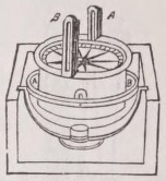
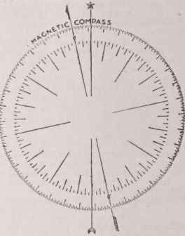
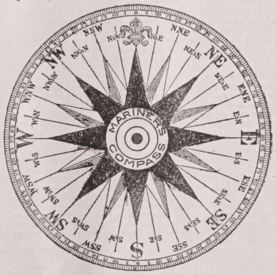
COMPASS, The Mariner’s, consists of three principal parts,—the card, the needle on its lower surface, and the case. The whole is enclosed in the compass-box, or binnacle. The term compass is said to have been applied to the instrument because the card involves or compasses the whole plane of the horizon, or because the needle indicates the whole circle of possible variations of direction. The surface of the card is divided by radiating lines into 32 parts, each containing 1 l o 15'; these constitute the 32 points or rhumbs; the half-points and quarters are subdivisions of the same. The north pole is denoted on the card by a fleur-de-lis ; and the line which joins the north and south poles passes through the axis of the needle. The points are named according to their proximity to the four cardinal points; for instance, the point mid-way between N. and N.E. is called north-north-east, being nearer north than east, and is marked N.N.E; the point mid-way between N. and N.N.E. is termed north by east, and is marked N. by E. The circumference of the card is sometimes divided into 360°. The divisions of the card are shown in the accompanying figure. The card is directed by the needle, which, with it, is pivoted on a vertical axis. With a little variation, the needle points nearly to the geographical north, and hence the mode of steering by the compass. Four or more parallel magnets, with like poles pointing in like directions, may be combined to form the needle; and by this arrangement the magnetic moment is increased for a given weight of steel. The needle is usually suspended on a central cap of ruby or agate, the point of suspension being of a similar hard material. On the inside of the compass-box is a vertical line known as lubber’s point; and since this and the ...pivot of the card are in the same plane with the ship’s keel, the point on the circumference of the card opposite to lubber’s point shows the angle the ship’s course makes with the magnetic meridian. The compass is kept horizontal by the use of a gimbal, or ring moving freely on an axis, wslthin which it swings on an axis at right angles. In the azimuth compass the circumference of the card is divided into degrees and parts by a vernier, and is fitted up with sight-vanes to take amplitudes and azimuths, for the purpose of determining the variation of the compass by observation. The variation is applied to the magnetic course shown by the steering compass, and thus the true course with respect to the meridian becomes known.
The conditions that chiefly affect the use of the mariner’s compass are those of the magnetic declination and deviation. The declination is the angle contained between the geographical or true and the magnetic meridian; or, as Barlowe defines it, the swerving of the pointing of the magnetical needle in the horizon from the meridian line there. The angle of declination varies according to locality, and must be ascertained at sea by means of the azimuth compass. The discovery of the variation of declination was made by Stephen Burrowes when voyaging between the north cape of Finmark and Vaigatch (Vay-gates),and was afterwards determined by Gillebrand, professor of geometry at Gresham College. In 1683, in a communication to the Royal Society (Phil. Trans., June 16, p. 214), Dr E. Halley shows that the irregularity observed in the variations of the compass at sea is not due to the attraction of the land, and comes to the conclusion that the whole globe of the earth is one great magnet, having four magnetical poles or points of direction. The declination for any place is subject to secular variations: thus, at Paris in 1681, it was 2° 30' to the W., in 1865 it was 18° 44' W. Halley, in a paper entitled “Account of the Cause of the Change of the Variation of the Magnetical Needle” (Phil. Trans., Oct. 19, 1692, pp. 563-578), points out, with other instances of secular variation, that between 1580 and 1692 the direction of the needle at Loudon changed from ll 0 15' E. to 6° W., or more than 17°, and demonstrates that.the direction is in no place fixed or constant, though in some places it changes faster than in others. Besides the secular, there are annual and diurnal variations of small amount. The existence of the latter was discovered by Mr Graham about 1719. The deviation of the compass is the departure of the north and south line from the magnetic meridian, owing to the magnetism of the ship itself, or that induced in it by the earth’s magnetic force. It was first observed during 1772— 74 by Mr Wales, the astronomer of Captain Cook. When surveying along the coast of New Holland in 1801 and 1802, Captain Matthew Flinders made the discovery that there was a difference in the direction of the magnetic needle, according as his ship’s head pointed to the E. or W. —westerly in the former, easterly in the latter case. When the ship’s head was N. or S. the needle took the same direction, or nearly so, that it would on shore, and showed a variation from the true meridian which was about a medium between that given by it when east and when west. He found, also, that the error in variation was nearly proportionate to the number of points which the ship’s head was from the north or south. (Phil. Trans., 1805, p. 186.) The deviation in wooden shipscan be practically obviated, but in iron ships it has to be partly allowed for, partly compensated. Barlow used a correcting plate of iron to overcome the directive action on the compass due to the magnetism of wooden vessels. On Professor Airy’s method, the permanent magnetism of ships is compensated by a steel magnet placed at a given distance below the compass; it is, however, liable to changes of intensity, occasioned by shocks, vibration, unequal heating, and other causes, a fact which led the late Dr Scoresby to propose the employment of a compass aloft, out of the region of the ship’s influence. The induced magnetism of ships can be only imperfectly compensated, since it varies according to the ship’s bearing, and as she rolls and pitches; but corrections can be made for the heeling error. The discovery of the dip of the magnetic needle is ascribed by Gilbert to Robert Norman, a nautical instrument maker at Wapping, who, about 1590, introduced the employment of a sliding weight on the needle for the correction of the dip at different points of the earth’s surface.
The earliest references to the use of the compass are to be found in Chinese history, from which we learn how, in the sixty-fourth year of the reign of Ho-ang-ti (2634 b.c.), the emperor Hiuan-yuan, or Ho-ang-ti, attacked one Tchi-yeou, on the plains of Tchou-lou, and finding his army embarrassed by a thick fog raised by the enemy, constructed a chariot (Tchi-nan) for indicating the south, so as to distinguish the four cardinal points, and was thus enabled to pursue Tchi-yeou, and take him prisoner. (Klaproth, Lettre à Μ. le Baron Humboldt sur l'invention de la Boussole, Paris, 1834. See also Mailla, Histoire générale de la Chine, torn i. p. 316, Paris, 1777.) Several other allusions to the compass are contained in early Chinese records, r ∏ιe power of the loadstone to communicate polarity to iron is said to be for the first time explicitly mentioned in a Chinese dictionary, finished in 121 a.d., where the loadstone is defined as “a stone with which an attraction can be given to the needle.” The first mention of the use of the compass for the purpose of navigation—an art that has apparently retrograded rather than advanced among the Chinese—occurs in the Chinese encyclopaedia, Ρoei-wen-yun-fou, in which it is stated that under the Tsin dynasty, or between 265 and 419 A.D., “there were ships directed to the south by the needle.” The Chinese, Mr Davis informs us, once navigated as far as India, but their most distant voyages at present extend not further than Java and the Malay Islands to the south (The Chinese, vol. iii. p. 14, London, 1844). According to an Arabic manuscript, a translation of which was published by Eusebius Renaudot (Paris, 1718), they traded in ships to the Persian Gulf and Red Sea in the 9th century. Staunton, in vol. i. of his Embassy to China (London, 1797), after referring to the early acquaintance of the Chinese with the property of the magnet to point southwards, remarks (p. 445), “The nature and the cause of the qualities of the magnet have at all times been subjects of contemplation among the Chinese. The Chinese name for the compass is ting-nan-ching, or needle pointing to the south; and a distinguishing mark is fixed on the magnet’s southern pole, as in European compasses upon the northern one.” “The sphere of Chinese navigation,” he tells us (p. 447), “is too limited to have afforded experience and observation for forming any system of laws supposed to govern the variation of the needle. . . . The Chinese had soon occasion to perceive how much more essential the perfection of the compass was to the superior navigators of Europe than to themselves, as the commanders of the ‘Lion’ and ‘H indostan,’ trusting to that instrument, stood out directly from the land into the sea. The number of points of the compass, according to the Chinese, is twenty-four, which are reckoned from the south pole; the form also of the instrument they employ is different from that familiar to Europeans. The needle is peculiarly poised, with its point of suspension a little below its centre of gravity, and is exceedingly sensitive; it is seldom more than an inch in length, and is less than a line in thickness. It appears thus sufficiently evident that the Chinese are not indebted to Western nations fortheir knowledge of the use of the compass. “It may be urged," writes Mr T. S. Davies, “that the different manner of constructing the needle amongst the Chinese and European navigators shows the independence of the Chinese of us, as theirs is the worse method, and had they copied from us, they would have used the better one ’’ (Thomson’s British Annual, 1837, p. 291). On the other hand, it does not seem improbable that a knowledge of the mariner’s compass was communicated by them directly or indirectly to the early Arabs, and through the latter was introduced into Europe. Sismondi has remarked (Literature of Europe, vol i. ) that it is peculiarly characteristic of all the pretended discoveries of the Middle Ages that when the historians mention them for the first time they treat them as things in general use. Gunpowder, the compass, the Arabic numerals, and paper, are nowhere spoken of as discoveries, and yet they must have wrought a total change in war, in navigation, in science, and in education. Tiraboschi (Storia della Letteratura Italiana, tom. iv. lib. ii. p. 204, et seq., ed. 2., 1788), in support of the conjecture that the compass was introduced into Europe by the Arabs, adduces their superiority in scientific learning, and their early skill in navigation. He quotes a passage on the polarity of the loadstone from a treatise translated by Albertus Magnus, attributed by the latter to Aristotle, but apparently only an Arabic compilation from the works of various philosophers. As the terms Zoron and Aphron, used there to signify the south and north poles, are neither Latin nor Greek, Tiraboschi suggests that they may be of Arabian origin, and that the whole passage concerning the loadstone may have been added to the original treatise by the Arabian translators.
Dr W. Robertson asserts (Historical Disquisition concerning Ancient India, p. 227) that the Arabs, Turks, and Persians have no original name for the compass, it being called by them Bossola, the Italian name, which shows that the thing signified is foreign to them as well as the word. The Rev. G. P. Badger has, however, pointed out (Travels of Ludovico di Varthema, trans., J. W. Jones, ed. G. P. Badger, Hakluyt Soc., 1863, note, pp. 31 and 32) that the name of Bushla or Busba, from the Italian Bussola, though common among Arab sailors in the Mediterranean, is very seldom used in the Eastern seas,— Daïrah and Beit el-Ibrah (the Circle, or House of the Needle) being the ordinary appellatives in the Red Sea, whilst in the Persian Gulf Kiblah-nâmeh is in more general use. Robertson quotes Sir J. Chardin as boldly asserting “that the Asiatics are beholden to us for this wonderful instrument, which they had from Europe a long time before the Portuguese conquests. For, first, their compasses are exactly like ours, and they buy them of Europeans as much as they can, scarce daring to meddle with their needles themselves. Secondly, it is certain that the old navigators only coasted it along, which I impute to their want of this instrument to guide and instruct them in the middle of the ocean I have nothing but argument to offer touching this matter, having never met with any person in Persia or the Indies to inform me when the compass was first known among them, though I made inquiry of the most learned men in both countries. I have sailed from the Indies to Persia in Indian ships, when no European has been aboard but myself. The pilots were all Indians, and they used the forestaff and quadrant for their observations. These instruments they have from us, and made by our artists, and they do not in the least vary from ours, except that the characters are Arabic. The Arabs are the most skilful navigators of all the Asiatics or Africans; but neither they nor the Indians make use of charts, and they do not much want them; some they have, but they are copied from ours, for they are altogether ignorant of perspective." The observations of Chardin, who flourished between 1643 and 1713, cannot be said to receive support from the testimony of some earlier authorities. That the Arabs must have been acquainted with the compass, and with the construction and use of charts, at a period nearly two centuries previous to Chardin's first voyage to the East, may be gathered from the description given by Barros of a map of all the coast of India, shown to Vasco da Gama by a Moor of Guzerat (about the 15th July 1498), in which the bearings were laid down “after the manner of the Moors,’ or “with meridians and parallels very small (or close together), without other bearings of the compass; because, as the squares of these meridians and parallels were very small, the coast was laid down by these two bearings of N. and S., and E. and W., with great certainty, without that multiplication of bearings of the points of the compass usual in our maps, winch serves as the root of the others/’ Further, we learn from Osorio that the Arabs at the time of Gama “were instructed in so many of the arts of navigation, that they did not yield much to the Portuguese mariners in the science and practice of maritime matters.' (See The Three Voyages of Vasco da Gama, Hakluyt Soc., 1869; note to chap, xv by the Hon. H. E. J. Stanley, p. 138.) Also the Arabs that navigated the Red Sea at the same period are shown by Varthema to have used the mariner’s chart and compass (Travels, p. 31)
Again, it appears that compasses of a primitive description, which can hardly be supposed to have been brought from Europe, were employed in the East Indies certainly as early as several years previous to the close of the 16th century In William Barlowe's Navigator's Supply, published in 1597, we read:—“Some fewe yeeres since, it so fell out that I had severall conferences with two East Indians which were brought into England by master Candish [Thomas Cavendish], and had learned our language: The one of them was of Mamil∏a [Manilla] in the Isle of Luzon, the other of Miaco in Japan. I questioned with them concerning their shipping and manner of sayling. They described all things farre different from ours, and shewed, that in steade of our Compas, they use a ιnag-neticall needle of sixe ynches long, and longer, upon a pinne in a dish of white China earth filled with water; In the bottome whereof they have two crosse lines, for the foure principali windes; the rest of the divisions being reserved to the skill of their Pilots.’ 1 Baïlak Kibdjaki, also, an Arabian writer, shows in his Merchant's Treasure, a work given to the world in 1282, that the magnetized needle, floated on water by means of a splinter of wood or a reed, was employed on the Syrian seas at the time of his voyage from Tripoli to Alexandria (1242), and adds :—“They say that the captains who navigate the Indian seas use, instead of the needle and splinter, a sort of fish made out of hollow iron, which, when thrown into the water, swims upon the surface, and points out the north and south with its head and tail” (Klaproth, Lettre, p. 57). Furthermore, although the sailors in the Indian vessels in which Niccola de’Conti traversed the Indian seas in 1420 are stated to have had no compass, still, on board the ship in which Varthema, less than a century later, sailed from Borneo to Java, both the mariner’s chart and compass were used; it has been questioned, however, whether in this case the compass was of Eastern manufacture {Travels of Varthema, Introd, xciv., andp. 249). We have already seen that the Chinese as iate as the end of the 18th century made voyages with compasses on which but little reliance could be placed; and it may perhaps be assumed that the compasses early used in the East were mostly too imp,erfect to be of much assistance to navigators, and were therefore often dispensed with on customary routes. The simple water-compass is said to have been used by the Coreans •so late as the middle of the 18th century; and Dr T. Smith, writing in the Philosophical Transactions for 1683-4, says of the Turks (p. 439), “They have no genius for Sea-voyages, and consequently are very raw and unexperienced in the art of Navigation, scarce venturing to sail out of sight of land. I speak of the natural Turks, who trade either into the Hack Sea or some part of the Morea, or between Constantinople and Alexandria, and not of the Pyrats of Barbary, who are for the most part Renegade’s, and learnt their skill in Christendom The Turkish compass consists but of 8
points, the four Cardinal and the four Collateral.” That the value of the compass was thus, even in the latter part of the 17th century, so imperfectly recognized in the East may serve to explain how in earlier times that instrument, long after the first discovery of its properties, may have been generally neglected by navigators.
The Saracen geographer, Edrîsi, who lived about 1100, is said by Boucher to give an account, though in a confused manner, of the polarity of the magnet (Hallam, Mid. Ages, vol. iii. chap. 9, part 2); but the earliest definite mention as yet known of the use of the mariner’s compass in the Middle Ages occurs in a treatise entitled De Utensilibus, written by Alexander Neckam in the 12th century. He speaks there of a needle carried on board ship which, being placed on a pivot, and allowed to take its own position of repose, shows mariners their course when the polar star is hidden. In another work, De Naturis Herum, lib. ii. c. 89, he writes,— “Mariners at sea, when, through cloudy weather in the day which hides the sun, or through the darkness of the night, they lose the knowledge of the quarter of the world to which they are sailing, touch a needle with the magnet, which will turn round till, on its motion ceasing, its point will be directed towards the north" (W. Chappell, Nature, No. 346, June 15, 1876). The magnetical needle, and its suspension on a stick or straw in water, are clearly described in La Bible Guiot, a poem probably of the 13th century, by Guiot de Provins, wherein we are told that through the magnet (la manette or Vamanière), an ugly brown stone to which iron turns of its own accord, mariners possess an art that cannot fail them. A needle touched by it, and floated by a stick on water, turns its point towards the pole-star, and a light being placed near the needle on dark nights, the proper course is known {Hist, littéraire de la France, tom. ix. p. 199; Barbazan, Fabliaux, tom. ii. p....