
WIG , in Saxon, signifies war. It is found in some names.
Word of the Day: Catachrestical
1. A covering for the head, consisting of hair interwoven or united by a kind of network; formerly much worn by men.
2. A sort of cake.
1. A covering for the head, consisting of hair interwoven or united by a kind of network, either in imitation of the natural growth, or in abundant and flowing curls, worn to supply a deficiency of natural hair, or for ornament, or according to traditional usage, as a part of an official or professional dress, the latter especially in England by judges and barristers.
2. An old seal; -- so called by fishermen.
3. A kind of raised seedcake.
Wig
Encyclopedia Britannica
WIG. Artificial hair appears to have been worn from very ancient times, as is testified by well-made wigs recovered from Egyptian mummy figures. The full and flow ing locks which adorn the sculptured reliefs of human figures found at Nineveh also suggest that wigs were not unknown among the ancient Assyrians. In the 16 th century the fashion of wearing false hair became prevalent among ladies in Europe. At one period Elizabeth of England was possessed of no fewer than eighty attires of false hair. Mary of Scotland throughout her life was also in the habit of varying the attires of hair she wore; and much of the confusion which has arisen in connexion with her portraits is traceable to this circumstance. The periwig of the 16th century was, however, merely false hair worn like, and sometimes with, the real hair, as an adornment or to supply the defects of nature. It was not till the 17th century that the peruke was worn as a distinctive feature of costume; as such it was first employed by Louis XIII. when his hair failed. His successor, Louis XIV., did not adopt it till 1673. In the meantime it had been freely donned by courtiers and gallants of the era. Charles I. of England, while in Paris on his way to Spain, “shadowed himself the most he could under a burly perruque, which none in former days but bald-headed people used.” The wearing of the peruke became general in the days of Charles II. Pepys records that he parted with his own hair, and “paid £3 for a periwigg”; and on going to church in one he says, “it did not prove so strange as I was afraid it would.” About this time the peruke is described as “a counterfeit hair which men wear instead of their own, a thing much used in our days by the generality of our men, contrary to their forefathers.” The ...wig obtained its maximum development during the reign of Queen Anne, who was patroness of the full-bottomed wig,—a huge head-dress which covered the back and shoulders and floated down over the chest. In 1724 the peruke-makers advertised “full-bottom tyes, full bobs, minister’s bobs, naturals, half naturals, Grecian flyes, curley roys, airey levants, qu perukes, and bagg wiggs” among the variety of artificial head-gear which they supplied. Early in the reign of George III. the general fashion of wearing wigs began to wane and gradually died out; but among professional men the practice continued to hold its place, and it was by slow degrees that military officers and clergymen gave up the habit. The wig of the 17th century now holds its place only on the judicial bench, and with the speaker of the English House of Commons, barristers, and advocates; but even on the bench its use is being threatened. Wigs of course continue to be worn by many to make up for natural deficiencies; and on the stage the wig is, as in all times, an indispensable adjunct. Many of the modern stage wigs are made of jute, a fibre which lends itself to marvellously perfect imitations of human hair.
9th ed. Encyclopædia Britannica, vol. 24, p. 560
[533 words — estimated reading time: 4 minutes]
[533 words — estimated reading time: 4 minutes]
A kind of canvaslike cotton fabric, used to stiffen and protect the lower part of trousers and of the skirts of women's dresses, etc.; -- so called from Wigan, the name of a town in Lancashire, England.
Wigan
Encyclopedia Britannica
WIGAN, a municipal and parliamentary borough and market-town of Lancashire, England, is situated on the river Douglas and on the main line of the London and North Western Railway, 18 miles west-north-west of Manchester, 18 north-east of Liverpool, and 195 north-west of London. The Douglas is spanned by several bridges, and is connected with the Leeds and Liverpool Canal. There is also a branch canal by Leigh and Worsley to Manchester. The older portions of the town occupy the north bank of the river, the modern additions being chiefly on the south bank. The church of All Saints, Late Perpendicular, consisting of chancel with aisles and two chapels, was restored in 1630 and again in 1847 There are six other ecclesiastical parishes. The principal public buildings are the Royal Albert Edward Infirmary and Dispensary (1873, enlarged 1884), the public hall (1853), the borough courts and offices (1866), the arcade (1872), the market-hall (1877), the free public library (1878), the public baths (1882), and the county justices courts and offices (1888). The educational institutions include the free grammar school (founded by James Leigh in 1619 and rebuilt in 1876), the mining and mechanical school, and the mechanics’ institution. The charities are numerous but of small individual importance, their aggregate annual value amounting to about £2500. A public park of 27 acres was opened in 1878. The town owes much of its prosperity to its coal mines, which afford employment to a large proportion of the inhabitants and supply fuel for the factory furnaces. Mills for making hats were established at Wigan in 1482; and subsequently bell-founding and pottery-making were of some importance. The chief industry is now the maufacture of cotton fabrics; the town also possesses iron ...forges, iron and brass foundries, oil and grease works, railway waggon factories, and bolt, screw, and nail works. The population of the municipal and parliamentary borough (area 2188 acres) was 20,774 in 1831; by 1861 it had increased to 37,658, by 1871 to 39,110, and by 1881 to 48,194 (23,508 males and 24,686 females); in 1888 it was estimated at 55,000.
Wigan is situated at the junction of three Roman roads, and there was a ford across the river where Millgate now stands. Many Roman coins have been found in the neighbourhood; hence it is supposed that Wigan was an important Roman station. Numerous Danish barrows also exist in the neighbourhood. After the Conquest Newton (in which Wigan is situated) was bestowed on Roger de Poictou, but on account of his rebellion was forfeited to the crown. The rectory of Wigan existed before 1243, and the rector as lord of the manor received a charter for the town in the 30th year of Henry III. Wigan was a city of refuge for runaway slaves during the Middle Ages. It was one of the 120 boroughs selected to send members to parliament in 1306; but the privilege lay dormant until 1547. From the charter it received in the 24th year of Edward III., confirming its liberties, it is evident that it was already an important market town, while its fairs were on a large scale and regulated by special laws. It also received charters from Richard II. and Charles II. Leland refers to it as a paved town “as bigge as Warrington, and better builded.” Camden describes it as “neat and plentiful.” Wigan contributed £50 of ship-money to Charles I. in 1636. On the outbreak of the Civil War in 1642 it was occupied by the earl of Derby, and formed the central garrison for the king in Lancashire; but the entrenchments were taken by Sir John Seaton in 1643 after a desperate battle. It was again repossessed by the earl of Derby, but was retaken by Colonel Ashton in March, when the outworks and fortifications were demolished. On 25th August 1651 the earl of Derby was defeated at Wigan by Colonel Lilburne, when Sir Thomas Tyldesley was slain. A memorial pillar to Tyldesley was erected in 1679 and restored in 1882. The town was governed by a mayor, recorder, 12 aidermen, and 2 bailiffs till the charter of 2d William IV. Under the Municipal Act it was divided into five wards, and is governed by a mayor, recorder, 10 aidermen, and 30 councillors. It has a commission of the peace and a separate court of quarter sessions. In 1885 the number of its parliamentary representatives was reduced to one.
See Sinclair’s History of Wigan, 1S82.
9th ed. Encyclopædia Britannica, vol. 24, p. 560
[758 words — estimated reading time: 5 minutes]
[758 words — estimated reading time: 5 minutes]
Wigeon
Encyclopedia Britannica
WIGEON (French Vigeon, from the Latin Vipio), also called locally “Whewer” and “Whew” (names imitative of the whistling call-note of the male), the Anas penelope of Linnaeus and Mareca penelope of many modern ornithologists, one of the most abundant species of Ducks throughout the greater part of Europe and northern Asia, reaching northern Africa and India in winter. A good many pairs breed in the north of Scotland; but the nurseries of the vast numbers which resort in autumn to the waters of temperate Europe are in Lapland or farther to the eastward. Comparatively few breed in Iceland....
Intermediate in size between the Teal and the Mallard, and less showy in plumage than either, the drake Wigeon is a beautiful bird, with the greater part of his bill blue, his forehead cream-colour, his head and neck chestnut, passing into pinkish grey below and above into lavender-grey, which last, produced by the transverse undulations of fine black and white lines, extends over the back and upper surface of the wings, except some of the coverts, which are conspicuously white, and shows itself again on the flanks. The wings are further ornamented by a glossy green speculum between two black bars; the tail is pointed and dark; the rest of the lower parts is white. The female has the inconspicuous coloration characteristic of her sex among most of the Duck tribe. In habits the Wigeon differs not a little from most of the Anatinae. It greatly affects tidal waters during the season of its southern stay, and becomes the object of slaughter to hundreds of gunners on the coasts of Britain and Holland; but, when it resorts to inland localities, as it also does to some extent, it passes much of its time in grazing, especially by day, on the pastures which surround the lakes or moors that it selects.
The Wigeon occurs occasionally on the eastern coast of North America, and not uncommonly, it would seem, on the Pribyloff Islands in the Pacific. But the New World has two allied species of its own. One of them, M. americana (a freshly killed example of which was once found in a London market), inhabiting the northern part of that continent, and in winter reaching Central America and the West Indian islands as far as Trinidad, wholly resembles its Old-World congener in habits and much in appearance. But in it the pale frontlet and the rich chestnut are mingled into, as it were, a compromise of light warm brown, the white wing-coverts are wanting, and nearly all the plumage is subdued in tone. The other species, M. sibilatrix or chiloensis, inhabits the southern portion of South America and its islands, from Chili on the west to the Falklands on the east, and is easily recognized by its nearly white head, nape glossy with purple and green, and other differences. (a. n.)
9th ed. Encyclopædia Britannica, vol. 24, p. 561
[483 words — estimated reading time: 3 minutes]
[483 words — estimated reading time: 3 minutes]
1. A wig or wigs; false hair.
2. Any cover or screen, as red-tapism.
Swift; nimble. [This seems to be a dialectical form of quick.]
2. The wight of all the world who lovd thee best.
1. Weight.
3. A supernatural being.
Wight
Encyclopedia Britannica
WIGHT, Isle of, a small island in the English Channel, situated off the coast of Hampshire, between 50° 35' and 50° 46' N. lat. and 1° 34' and 1° 5' W. long, (see vol. xi. Pl. VII. ). It forms a portion of the county of Hampshire, and is separated from the mainland by a narrow strait, the Solent and Spithead. The island is, roughly speaking, diamond-shaped, the shorter diameter, from north to south, measuring 13 miles, and the longer, from east to west, 23 miles. The area is 92,931 acres, or about 145 square miles. The most prominent feature in its physical geography is a range of high chalk downs running from east to west across the centre of the island, and terminating in the Culver and Freshwater cliffs respectively. This range is broken through in the centre by the valley of the Medina, which flows due north and is the only river of consequence in the island; it is navigable up to Newport. A second smaller range of chalk downs .occurs in the south near Ventnor. Along the south coast, extending from St Catherine Point to Ventnor, there is the remarkable district known as the Undercliff, celebrated for its wild and romantic beauty and for its mild climate. It is sheltered from the north by a line of high cliffs. North of the central chalk range the country is for the most part flat and well-wooded. Parkhurst Forest, where* timber is grown for the use of the British navy, is 3000 acres in extent. The geology of the island affords within a small area abundant opportunities for studying many different formations. The uppermost of the strata represented in the island is the Eocene, and the lowest the Wealden. All the strata between these two may be studied in good sections, and very numerous and interesting fossils may be collected. The various Eocene beds are ...exhibited along the north coast, and may also be studied to great advantage in White Cliff and Alum Bays. In the neighbourhood of Gurnet Bay there is a very remarkable bed, containing beautifully-preserved remains of insects and spiders. In Alum Bay, in the extreme west, the strata are vertically disposed, and consist of a very curious series of coloured sands and clays. Here also the junction between the Eocene and the underlying Chalk is admirably shown. The central range of chalk downs is part of the northern slope, and the downs behind the Undercliff are part of the southern slope of a lesser anticlinal axis, the upper portion of the Chalk strata having been denuded in such a way as to expose the underlying Greensand, of which the greater portion of the southern half of the island is composed. The Greensand formation may best be studied in the cliff section from Atherfield Point to Rocken End. Beneath the Greensand the Wealden is exposed in the section from Brook to Atherfield, and also, to a much less extent, in Sandown Bay. The Wealden strata have yielded abundant fossil remains of extinct reptiles (Iguanodon), especially in the neighbourhood of Brook and Cowleaze Chines; and at Brook Point an extensive fossil forest exists, being the remains of a great raft of timber floated down and deposited in estuarine mud at the mouth of a great river. At Brook also the characteristic Wealden mollusk, Unio valdensis, occurs abundantly.
The climate is mild, and relaxing, and enjoys the reputation of being peculiarly salubrious. In winter and spring, however, the east winds are very trying, and in summer the heat is at times very great. The climate of the Undercliff is especially mild, and a large consumption hospital (the Royal National Hospital for Consumption and Diseases of the Chest), arranged on ιhe cottage principle, has been established here. Partly owing to the mildness of the climate, and partly to the beauty of the scenery, the island has long been a favourite resort of tourists, and λvithin recent years several fashionable watering-places have sprung up. Of these the principal are Cowes, at the mouth of the Medina, the headquarters of the Royal Yacht Squadron, Ryde (11,461 inhabitants in 1881), Bembridge, Sandown, Ventnor (5739), Shanklin (1780), Freshwater (2809), and Yarmouth (787). Newport (9357), on the Medina, is the capital of the island, but is comparatively little frequented by visiters. Hitherto many parts of the island have been more or less inaccessible owing to the deficiency of railways; but it is being rapidly opened up, and a railway is now in course of construction between Newport, Carisbrooke, Yarmouth, and Freshwater. There are few industries in the island. The population is chiefly agricultural, a large proportion of the land being devoted to sheepgrazing. Fishing is also carried on to a considerable extent on the south coast,—lobsters, crabs, and prawns being plentiful. Oyster cultivation has been attempted in the Medina, in Brading Harbour, and in the Newtown river. At Cowes shipbuilding is carried on, and on the Medina there are cement-works. In the towns, however, the chief occupation of the inhabitants consists in providing for the wants of the summer visiters; in winter very little business is done. The island is divided into two liberties, East and West Medina, excluding the two boroughs of Newport and Ryde; and it forms one petty and special sessional division of the county. Until 1885 there was one member of parliament for the island and one for the borough of Newport; now, however, there is only one member for the whole island. Episcopally the island has for many centuries belonged to the see of Winchester. In 1881 the population was 73,633, as against 66,219 in 1871.
History.— The Isle of Wight (Roman Vectis) was originally inhabited by Celts, and was conquered for the emperor Claudius by Vespasian in 43. The Romans remained in possession for four centuries. In 530 it was conquered by Cerdic and Cymric and added to the kingdom of W essex. Later on it again became free from the control of Wessex and remained independent until the inhabitants of their own accord submitted to Edward, the son of Alfred. William the Conqueror gave the island as an independent lordship to William Fitz-Osborne, but it was again forfeited to the crown on the rebellion of his son, the earl of Hereford. Henry I. gave the lordship to Richard de Redvers, in whose family it remained until 1293, when Isabella de Fortibus, the lady of the island, sold it to Edward I. Richard II. again appointed a lord of the island, and the office continued until the reign.of Henry VII., when it was finally abolished. From that date onwards the government has been vested in a captain or governor, whose office is now honorary. Charles I. was confined in Carisbrooke Castle for some time in 1649. The antiquities include the British pit villages near
Rowborough, the Celtic tumuli on several of the chalk downs, the long stone at Mottistone, the Roman villas near Brading and Carisbrooke, the ruins of Quarr Abbey, and numerous ancient churches. Carisbrooke Castle, almost in the centre of the island, is a fine old ruin built upon the site of an ancient British stronghold. The British fortifications were probably occupied as a camp by the Romans under Vespasian, and they were subsequently held by the Saxons, who made the high mound known as the keep. The inner walls of the castle were erected in the 11th century, and the outer defences were constructed in the reign of Elizabeth. The Roman villa near Brading contains some beautiful and well-preserved examples of tesselated pavements; that at Carisbrooke is smaller and not so interesting.
9th ed. Encyclopædia Britannica, vol. 24, p. 561
[1,279 words — estimated reading time: 8 minutes]
[1,279 words — estimated reading time: 8 minutes]
Wigtown
Encyclopedia Britannica
WIGTOWN, or Wigton, a maritime county in the south-west corner of Scotland, forming the western division of the old. district of Galloway, is bounded N. by the Irish Channel and Ayrshire, E. by Kirkcudbright and Wigtown Bay, S. by the Irish Sea, and W. by the Irish Channel. It is of very irregular form. Its greatest breadth, east and west, is about 33 miles and its greatest length, north and south, about 26 miles. The area is 310,742 acres or 485∣ square miles....
Physical Features.— The coast-line has a total length of about 120 miles. On the eastern boundary the estuary of the Cree expands into Wigtown Bay. Between Wigtown and Luce Bays is the peninsula of the Machers, of which Burrow Head is the southern extremity. Luce Bay has a length of about 15 miles and an average breadth of 12. By its indentation on the south and that of Loch Ryan (about 9 miles long and nearly 3 broad) on the north the two-pronged peninsula of the Rinns is formed, of which the Mull of Galloway, the most southerly point in Scotland, is the southern extremity, and Kirkcolm Point the northern. The coast is more or less precipitous, with many small inlets, few of which, on account of dangerous hidden rocks, afford suitable landing-places for vessels. Loch Ryan forms, however, a splendid natural harbour, of which Stranraer is the port. Portpatrick on the Irish Channel is the nearest port in Great Britain to Ireland, and 7 miles to the south is Port Logan. With the exception of Port William on its eastern shore, Luce Bay is destitute of harbours. Wigtown Bay includes on the Wigtown side the small harbours of the Isle of Whithorn, Garliestown, Wigtown, and Carty, but the upper portions of the bay are not navigable at low water. The county is occupied almost solely by Silurian strata, its characteristic feature being a series of rocky hills, which extend more or less over the whole county, attaining their highest elevation in the north, on the borders of Ayrshire. A considerable number range between 400 and 800 feet in altitude, the highest summits being Miltonish (970 feet), on the northern border, and Craigairie Fell (1000 feet) in Kirkcowan parish. A great part of the county has a wild and bleak appearance, the hills being covered with heath and whins, while in the lower parts there are long stretches of bog and moss. The Silurian rocks are in some parts interpenetrated by small areas of granite; and immense granite boulders are occasionally scattered over the lower grounds, doubtless the result of the Glacial action of the Kirkcudbrightshire ice bed. Along the western edge of Loch Ryan there is a narrow band of Carboniferous strata, consisting of sandstones which have been classed as calciferous. They rest unconformably on a narrow belt of Permian strata separating them from the Silurian rocks. In the Carboniferous strata various plant impressions are met with. Between Luce Bay and Loch Ryan, and on the upper shores of Wigtown Bay, there are raised beaches. Galena, copper pyrites, and barytes have been found in small quantities; grey shales for roofing slates and flags for pavement are dug at Cairn Ryan on the eastern shores of Loch Ryan, where sandstone is also quarried for building purposes; from the clays in the neighbourhood of Stranraer bricks are manufactured. Owing to the irregular hilly character of the county the streams, though numerous, are generally small. The Cree, forming the boundary with Kirkcudbrightshire, flows past Newton Stewart and Carty into Wigtown Bay; the Bladenoch, from Loch Maberry on the Ayrshire border, falls into Wigtown Bay at the town of Wigtown, after having received the Tarf, the Malzie, and the Black Burn; and the Luce, formed by the junction of the Main Water and the Cross Water at New Luce, flows south into Luce Bay. There are a very large number of lochs, but none of them very extensive, the principal being the beautiful one in Inch parish included in the grounds of Castle Kennedy, Lochs Maberry and Dornal on the Ayrshire border, Loch Connel in Kirkcolm parish, Loch Ronald in Kirkcowan parish, and Castle Loch and the four lochs of Mochrum in Mochrum parish. Dowalton Loch, at the junction of Kirkinner, Sorbie, and Glasserton parishes, was drained in 1862.
Agriculture. —Although the rainfall exceeds the average in Scotland, the climate is not specially unfavourable for the ripening of crops, and frosts are not generally of long continuance. A considerable portion of Wigtownshire consists of stony moors, which have insufficient soil to render reclamation possible. Along the shores there is some extent of gravelly soil, which, however, requires heavy manuring to render it fruitful. Where the higher districts are arable a rocky soil prevails, better adapted for grass and green crops than for corn crops. A large extent of the county is black top reclaimed from moors; in other districts loam and clay prevail. The most common method of cropping is a six years’ shift of oats, green crops, corn crop, and three years’ grass. According to the Agricultural Returns for 1887, the arable area was 147,063 acres or about 46 per cent, of the whole, considerably above the average for even the lowland counties of Scotland. The area under corn crops was 37,392 acres, of which 35,511 were under oats. The latter area has not materially changed within the last thirty years, the chief diminution having been in wheat, which in 1855 occupied 7343 acres and in 1887 only 736. Barley and bere in 1887 occupied 796 acres, rye 38, and beans 310. The bulk of the green crops consists of turnips and swedes, occupying in 1887 15,678 acres, whilst 1902 acres were potatoes, 229 mangold, 100 carrots, 153 cabbage, &c., and 135 vetches. There were 69,326 acres under clover and rotation grasses and 21,883 under permanent pasture. In 1881 (the latest return) there were over 8009 acres under woods, and in 1887 there were 40 under nursery grounds, 6 under market gardens, and 7 under orchards. The large area under grass and turnips is owing to the general prevalence of dairy farming. In 1887 the number of cattle was 42,062, of which 21,197 were milch cows, a number exceeded in only four other counties in Scotland, although in the number of its cattle it is surpassed by ten counties. The Galloway cattle, a black polled breed, are now chiefly confined to the eastern districts, the Ayrshire being found a much more suitable breed for dairy purposes. In some cases Galloway bulls are kept for breeding with Ayrshire cows. Many dairy farms send milk to Glasgow and the neighbouring towns; but the manufacture of cheese has greatly increased within late years, large cheese factories having been established. Dunlop is now almost wholly superseded by Cheddar cheese. Horses, chiefly Clydesdale, for which breed Wigtownshire has acquired some fame, numbered 5699 in 1887; sheep, chiefly blackfaced on the hilly farms, and in other districts crosses with Leicesters and other long-woolled breeds, numbered 116,264; and pigs 10,380. From 1345 returns obtained from occupiers of land in 1887, out of 147,104 acres 142,266 were rented and occupied and 4838 owned and occupied. The following table gives a classification of agricultural holdings according to size in 1880 and 1885 :— [table]
According to the latest landowners’ Return, the county was divided among 1820 proprietors, possessing 309,087 acres at an annual value of £230,589, or about 14s. lid. per acre. Of the proprietors 1674 possessed less than one acre each. The following owned over 5000 acres each :—earl of Stair, 79,174; E. J. S. Blair, 37,268; earl of Galloway, 23,203; marquis of Bute, 20,157; Sir W. Maxwell, 16,877; James M ’ Douall, 16,290; Sir Andrew Agnew, 12,962; D. Hunter Blair, 8255; William Maitland, 7848; Sir J. Dalrymple Hay, 7400; R. Vans Agnew, 6777; W. C. S.
cloister, and a small portion of the church in the Early English
Hamilton, 6300; Mrs S. Ο. Μ‘Taggart, 5998; Lieut.-Col. Sir W. T. F. Agnew Wallace, 5785; and R. H. J. Stewart, 5552. Communication.— The Portpatrick Railway crosses the county from Newton Stewart by Kirkcowan, Glenluce, and Stranraer to Portpatrick. From Newton Stewart the Wigtownshire Railway passes south by Wigtown and Garliestown to Whithorn. The Girvan and Portpatrick Railway branches off from the Portpatrick line at East Challoch near Dunragit and passes northwards by New Luce. There is a line of steamers to Ireland by Portpatrick.
Manufactures and Trade.— Although agriculture is the main industry, there is a variety of small manufactures in the towns, including a woollen factory at Kirkcowan, engineering and locomotive works at Stranraer, hand-loom weaving in various places, distilling, tanning, and currying. The fishing industry is of almost no account. There is, however, an oyster fishery in Loch Ryan, and herrings are caught in Loch Ryan and the Bay of Luce. The value of the salmon fisheries, including those of the rivers, is less than £1000 a year.
Administration and Population.— From 22,918 in 1801 the population had by 1821 increased to 33,240 and by 1851 to 43,389; but it declined to 42,095 in 1861, to 38,830 in 1871, and to 38,611 (males 18,143, females 20,468) in 1881. In point of density Wigtown stands twenty-first among the counties of Scotland, the number of persons to the square mile being 79. The proportion of females to every 100 males was 112'82, the largest proportion of any county with the exceptions of Orkney and Shetland and Forfar. The number of persons who could speak Gaelic was only twentyeight. The town population in 1881 numbered 9060, the village 8574, and the rural 20,977. The county has three royal burghs— Wigtown (1789), Stranraer (3455), and Whithorn (1643). The last two are also police burghs (Stranraer, 6342). Part (2645) of the police burgh of Newton Stewart is within the county, the remainder being in Kirkcudbrightshire. Newton Stewart is also a burgh of barony, as are likewise Glenluce (901) and Portpatrick (591). The county returns one member to parliament. Formerly Wigtown, Stranraer, and Whithorn formed with New Galloway a group of burghs returning one member, but by the Act of 1885 they were merged in the county. The county includes seventeen parishes. Wigtownshire is in the same sheriffdom as the counties of Kirkcudbright and Dumfries. Sheriff courts are held during certain periods at Wigtown and Stranraer, and quarter sessions are held at Wigtown and Glenluce.
History and Antiquities.— The portion of Galloway now forming Wigtownshire was in early times occupied chiefly by the Novantae. When the district was overrun by the Romans under Agricola in 82, they fixed their headquarters at Whithorn (Leucophibia), and one of their principal stations, Rerigonium, was on the eastern shore of Loch Ryan. The Devil’s dyke, a defensive work of the Romans, extended from Loch Ryan to the upper part of the Solway Firth. A sketch of the early history of Galloway, including Wigtownshire, is given-under Kirkcudbright (vol. xiv. p. 98). The district was the scene of the labours of the Christian missionary St Ninian (q.v.), who arrived at Whithorn (Candida Casa) towards the close of the 4th century. Whithorn was a bishop’s see from 727 till the Reformation. In addition to the caves on the sea coast, which, like those of Kirkcudbrightshire, are associated with early human occupation, the ancient inhabitants have left traces of themselves in cairns, standing stones, hut circles, and remains of ancient villages. Numerous early relics have also been dug up, including flint and other stone implements, as well as a great variety of ancient bronze implements and ornaments. The Dowalton crannogs were the first lake dwellings discovered in Scotland, and are among the most remarkable in the country. Among the ancient fortalices may be mentioned the sea towers of Carghidown and Castle Feather, south of Whithorn; the ruins of Baldoon, south of Wigtown, associated with events which suggested to Scott the tale of the Bride of Lammermoor ; the tower of Corsewall near the west shore of Loch Ryan; the foundations of a Norse stronghold in Cruggleton Bay; Dunskey at the head of Castle Bay, built in the 16th century, but occupying the site of an ancient fortress; the fragments of Long Castle at Dowalton Loch, the ancient seat of the
M‘Doualls; the castle of Mochrum and Myrtoun Castle, the seat of the Maccullochs, in Mochrum parish; and the ruined tower of Sorbie, the ancient keep of the Hannays. Of the Cistercian abbey of Glenluce, founded in 1190 by Roland, lord of Galloway, the principal remains are the chapter house in the Decorated style, the walls of the style. The ancient cathedral of Whithorn, though in a dilapidated condition, forms a picturesque ruin, and near it are some slight remains of the ancient priory founded by St Ninian. The Dominican priory of Wigtown, founded in 1267, has, like the ancient castle, entirely disappeared; and only some slight mounds remain of Saulseat abbey, founded for Premonstratensians by Fergus, lord of Galloway, in 1148. Wigtown was probably created a sheriffdom in the 13th century. In 1341 the earldom of Wigton, which included the whole of the county, with the jurisdiction of a regality, was bestowed upon Sir Malcolm Fleming. In 1372 the earldom was purchased by Archibald Douglas, who the same year was created lord of Galloway. In the reign of James I. William Douglas of Leswalt was sheriff of Wigtown and keeper of the castle of Lochnaw; but in 1426 the constableship of Lochnaw, with the sheriffdom of Wigtown, was acquired by Andrew Agnew. These dignities continued to be held by the Agnew family tül 1682, when Sir Andrew Agnew refused to take the test and was superseded by Graham of Claverhouse. At the Restoration in 1688 the office of sheriff was restored to the Agnew family, and they held it till the abolition of hereditary jurisdictions in 1747. The principal modern mansions are Galloway House, built in 1740, the seat of the earls of Galloway; Castle Kennedy, built by the first earl of Stair after the destruction of the old castle by fire in 1716; the baronial castle of Lochnaw, including, with large modern additions, the battlemented tower of the ancient building; and Barnbarroch House, the seat of R. Vans Agnew.
See Symson, Description of Galloway, 1823; Murray, Literary History of Galloway, 1882; Sir Andrew Agnew, Hereditary Sheriffs of Galloway, 1864; Histories of Galloway, by Mackenzie, 1841, and P. II. Mackerlie, 1870-78.
9th ed. Encyclopædia Britannica, vol. 24, p. 562 — signed T. F. H.
[2,444 words — estimated reading time: 14 minutes]
[2,444 words — estimated reading time: 14 minutes]
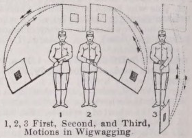
To signal by means of a flag waved from side to side according to a code adopted for the purpose.
Clothing Roget’s Thesaurus §225
N. clothing, investment, covering, dress, raiment, drapery, costume, attire, guise, toilet, toilette, trim, habiliment, vesture, vestment, garment, garb, palliament|, apparel, wardrobe, wearing apparel, clothes, things, underclothes, array, tailoring, millinery, finery, full dress, garniture, theatrical properties, outfit, equipment, trousseau, uniform, regimentals, continentals, canonicals, livery, gear, harness, turn-out, accouterment, caparison, suit, rigging, trappings, traps, slops, togs, toggery, day wear, night wear, zoot suit, designer clothes, masquerade, dishabille, morning dress, undress, kimono, lungi, shooting-coat, mufti, rags, tatters, old clothes, mourning, weeds, duds, slippers, robe, tunic, paletot, habit, gown, coat, frock, blouse, toga, smock frock, claw coat, hammer coat, prince albert coat, sack coat, tuxedo coat, frock coat, dress coat, tail coat, cloak, pall, mantle, mantlet mantua, shawl, pelisse, wrapper, veil, cape, tippet, kirtle, plaid, muffler, comforter, haik, huke|, chlamys, mantilla, tabard, housing, horse cloth, burnoose, burnous, roquelaure, houppelande, surcoat, overcoat, great coat, surtout, spencer, mackintosh, waterproof, raincoat, ulster, p- coat, dreadnought, wraprascal, poncho, cardinal, pelerine, barbe, chudder, jubbah, oilskins, pajamas, pilot jacket, talma jacket, vest, jerkin, waistcoat, doublet, camisole, gabardine, farthingale, kilt, jupe, crinoline, bustle, panier, skirt, apron, pinafore, bloomer, bloomers, chaqueta, songtag, tablier, pants, trousers, trowsers, breeches, pantaloons, inexpressibles|, overalls, smalls, small clothes, shintiyan|, shorts, jockey shorts, boxer shorts, tights, drawers, panties, unmentionables, knickers, knickerbockers, philibeg, fillibeg, pants suit, culottes, jeans, blue jeans, dungarees, denims, levis, calvin klein, calvins, bonjour, gloria vanderbilt, headdress, headgear, chapeau, crush hat, opera hat, kaffiyeh, sombrero, jam, tam-o-shanter, tarboosh, topi, sola topi, pagri, puggaree, cap, hat, beaver hat, coonskin cap, castor, bonnet, tile, wideawake, billycock, wimple, nightcap, mobcap, skullcap, hood, coif, capote, calash, kerchief, snood, babushka, head, coiffure, crown, chignon, pelt, wig, front, peruke, periwig, caftan, turban, fez, shako, csako, busby, kepi, forage cap, bearskin, baseball cap, fishing hat, helmet, mask, domino, body clothes, linen, hickory shirt, shirt, sark, smock, shift, chemise, night gown, negligee, dressing gown, night shirt, bedgown, sac de nuit, underclothes, underpants, undershirt, slip, brassiere, corset, stays, corsage, corset, corselet, bodice, girdle, stomacher, petticoat, panties, under waistcoat, jock, athletic supporter, jockstrap, sweater, jersey, cardigan, turtleneck, pullover, sweater vest, neckerchief, neckcloth, tie, ruff, collar, cravat, stock, handkerchief, scarf, bib, tucker, boa, cummerbund, rumal, rabat, shoe, pump, boot, slipper, sandal, galoche, galoshes, patten, clog, sneakers, running shoes, hiking boots, high-low, blucher boot, wellington boot, hessian boot, jack boot, top boot, balmoral, arctics, bootee, bootikin, brogan, chaparajos, chavar, chivarras, chivarros, gums, larrigan, rubbers, showshoe, stogy, veldtschoen, legging, buskin, greave, galligaskin, gamache, gamashes, moccasin, gambado, gaiter, spatterdash, brogue, antigropelos, stocking, hose, gaskins, trunk hose, sock, hosiery, glove, gauntlet, mitten, cuff, wristband, sleeve, swaddling cloth, baby linen, layette, ice wool, taffeta, pocket handkerchief, hanky, hankie, clothier, tailor, milliner, costumier, sempstress, snip, dressmaker, habitmaker, breechesmaker, shoemaker, crispin, friseur, cordwainer, cobbler, hosier, hatter, draper, linen draper, haberdasher, mercer, diaper, nappy, disposable diaper, cloth diaper, luvs, huggies
V. invest, cover, envelope, lap, involve, inwrap, enwrap, wrap, fold up, wrap up, lap up, muffle up, overlap, sheath, swathe, swaddle, roll up in, circumvest, vest, clothe, array, dress, dight, drape, robe, enrobe, attire, apparel, accounter, rig, fit out, deck, perk, equip, harness, caparison, wear, don, put on, huddle on, slip on, mantle
Adj. invested, habited, dighted, barbed, barded, clad, costume, shod, chausse, en grande tenue, sartorial
Phr. "the soul of this man is his clothes"
No Bible verses found for "wig".